


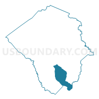
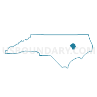
Voting District 1301, Pitt County, North Carolina
About
Outline

Summary
| Unique Area Identifier | 641173 |
| Name | Voting District 1301 |
| County | Pitt County |
| State | North Carolina |
| Area (square miles) | 31.43 |
| Land Area (square miles) | 31.43 |
| Water Area (square miles) | 0.00 |
| % of Land Area | 100.00 |
| % of Water Area | 0.00 |
| Latitude of the Internal Point | 35.42636070 |
| Longtitude of the Internal Point | -77.30764840 |
Maps

Graphs
Select a template below for downloading or customizing gragh for Voting District 1301, Pitt County, North Carolina


Neighbors
Neighoring Voting District (by Name) Neighboring Voting District on the Map
- Voting District 0200B, Pitt County, NC
- Voting District 0601, Pitt County, NC
- Voting District 1001, Pitt County, NC
- Voting District 14, Craven County, NC
- Voting District 1402A, Pitt County, NC
- Voting District 1402B, Pitt County, NC
- Voting District 1403A, Pitt County, NC
- Voting District 15, Craven County, NC
Top 10 Neighboring County Subdivision (by Population) Neighboring County Subdivision on the Map
- Winterville township, Pitt County, NC (46,280)
- Township 1, Craven County, NC (8,656)
- Ayden township, Pitt County, NC (7,525)
- Chicod township, Pitt County, NC (6,645)
- Grifton township, Pitt County, NC (4,900)
- Swift Creek township, Pitt County, NC (1,669)
Top 10 Neighboring Unified School District (by Population) Neighboring Unified School District on the Map
Top 10 Neighboring State Legislative District Lower Chamber (by Population) Neighboring State Legislative District Lower Chamber on the Map
Top 10 Neighboring State Legislative District Upper Chamber (by Population) Neighboring State Legislative District Upper Chamber on the Map
- State Senate District 5, NC (183,899)
- State Senate District 2, NC (183,118)
- State Senate District 3, NC (167,669)
Top 10 Neighboring 111th Congressional District (by Population) Neighboring 111th Congressional District on the Map
Top 10 Neighboring Census Tract (by Population) Neighboring Census Tract on the Map
- Census Tract 9602, Craven County, NC (8,637)
- Census Tract 13.03, Pitt County, NC (7,689)
- Census Tract 12, Pitt County, NC (5,939)
- Census Tract 14.02, Pitt County, NC (2,591)
Top 10 Neighboring 5-Digit ZIP Code Tabulation Area (by Population) Neighboring 5-Digit ZIP Code Tabulation Area on the Map
- 27858, NC (55,781)
- 28590, NC (23,407)
- 28513, NC (10,346)
- 28586, NC (8,218)
- 28530, NC (7,332)
- 27837, NC (5,903)