


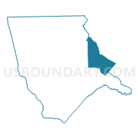
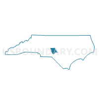
Voting District CAM, Moore County, North Carolina
About
Outline

Summary
| Unique Area Identifier | 640929 |
| Name | Voting District CAM |
| County | Moore County |
| State | North Carolina |
| Area (square miles) | 44.58 |
| Land Area (square miles) | 44.40 |
| Water Area (square miles) | 0.18 |
| % of Land Area | 99.60 |
| % of Water Area | 0.40 |
| Latitude of the Internal Point | 35.33285450 |
| Longtitude of the Internal Point | -79.28072280 |
Maps

Graphs
Select a template below for downloading or customizing gragh for Voting District CAM, Moore County, North Carolina


Neighbors
Neighoring Voting District (by Name) Neighboring Voting District on the Map
- Voting District C, Lee County, NC
- Voting District CAR, Moore County, NC
- Voting District D, Lee County, NC
- Voting District LTR, Moore County, NC
- Voting District PR16, Harnett County, NC
- Voting District VSS, Moore County, NC
Top 10 Neighboring County Subdivision (by Population) Neighboring County Subdivision on the Map
- Township 7, McNeill, Moore County, NC (18,592)
- Johnsonville township, Harnett County, NC (10,808)
- Township 1, Greenwood, Lee County, NC (8,885)
- Township 1, Carthage, Moore County, NC (6,820)
- Township 7, Pocket, Lee County, NC (5,029)
- Township 6, Greenwood, Moore County, NC (3,877)
- Township 10, Little River, Moore County, NC (3,760)
- Township 5, Deep River, Moore County, NC (409)
Top 10 Neighboring Place (by Population) Neighboring Place on the Map
Top 10 Neighboring Unified School District (by Population) Neighboring Unified School District on the Map
- Harnett County Schools, NC (114,678)
- Moore County Schools, NC (88,247)
- Lee County Schools, NC (57,866)
Top 10 Neighboring State Legislative District Lower Chamber (by Population) Neighboring State Legislative District Lower Chamber on the Map
- State House District 51, NC (92,118)
- State House District 54, NC (83,728)
- State House District 52, NC (83,301)
Top 10 Neighboring State Legislative District Upper Chamber (by Population) Neighboring State Legislative District Upper Chamber on the Map
Top 10 Neighboring 111th Congressional District (by Population) Neighboring 111th Congressional District on the Map
Top 10 Neighboring Census Tract (by Population) Neighboring Census Tract on the Map
- Census Tract 714.02, Harnett County, NC (8,528)
- Census Tract 9505.02, Moore County, NC (8,128)
- Census Tract 305.03, Lee County, NC (7,296)
- Census Tract 9505.01, Moore County, NC (6,438)
- Census Tract 306.02, Lee County, NC (4,711)
- Census Tract 9504.02, Moore County, NC (4,283)
- Census Tract 714.01, Harnett County, NC (3,908)