


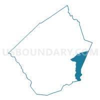
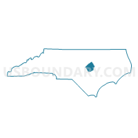
Voting District PR07, Johnston County, North Carolina
About
Outline

Summary
| Unique Area Identifier | 640564 |
| Name | Voting District PR07 |
| County | Johnston County |
| State | North Carolina |
| Area (square miles) | 37.81 |
| Land Area (square miles) | 37.73 |
| Water Area (square miles) | 0.08 |
| % of Land Area | 99.79 |
| % of Water Area | 0.21 |
| Latitude of the Internal Point | 35.45119720 |
| Longtitude of the Internal Point | -78.16171180 |
Maps

Graphs
Select a template below for downloading or customizing gragh for Voting District PR07, Johnston County, North Carolina


Neighbors
Neighoring Voting District (by Name) Neighboring Voting District on the Map
- Voting District 01, Wayne County, NC
- Voting District 03, Wayne County, NC
- Voting District 08, Wayne County, NC
- Voting District 24, Wayne County, NC
- Voting District PR04, Johnston County, NC
- Voting District PR06, Johnston County, NC
- Voting District PR08, Johnston County, NC
- Voting District PR19, Johnston County, NC
- Voting District PR22, Johnston County, NC
Top 10 Neighboring County Subdivision (by Population) Neighboring County Subdivision on the Map
- Fork township, Wayne County, NC (11,149)
- Boon Hill township, Johnston County, NC (7,283)
- Buck Swamp township, Wayne County, NC (7,157)
- Pine Level township, Johnston County, NC (4,852)
- Beulah township, Johnston County, NC (4,311)
- Grantham township, Wayne County, NC (4,264)
- Micro township, Johnston County, NC (2,812)
- Great Swamp township, Wayne County, NC (2,362)
- Bentonville township, Johnston County, NC (1,929)
Top 10 Neighboring Place (by Population) Neighboring Place on the Map
Top 10 Neighboring Unified School District (by Population) Neighboring Unified School District on the Map
Top 10 Neighboring State Legislative District Lower Chamber (by Population) Neighboring State Legislative District Lower Chamber on the Map
- State House District 26, NC (95,937)
- State House District 28, NC (93,901)
- State House District 11, NC (78,345)
Top 10 Neighboring State Legislative District Upper Chamber (by Population) Neighboring State Legislative District Upper Chamber on the Map
Top 10 Neighboring 111th Congressional District (by Population) Neighboring 111th Congressional District on the Map
Top 10 Neighboring Census Tract (by Population) Neighboring Census Tract on the Map
- Census Tract 11.01, Wayne County, NC (7,820)
- Census Tract 1.01, Wayne County, NC (7,215)
- Census Tract 401, Johnston County, NC (6,942)
- Census Tract 405, Johnston County, NC (6,351)
- Census Tract 413, Johnston County, NC (5,991)
- Census Tract 404, Johnston County, NC (4,407)
- Census Tract 10, Wayne County, NC (4,230)
Top 10 Neighboring 5-Digit ZIP Code Tabulation Area (by Population) Neighboring 5-Digit ZIP Code Tabulation Area on the Map
- 27530, NC (40,117)
- 27577, NC (22,911)
- 27576, NC (17,091)
- 27863, NC (11,735)
- 27542, NC (9,133)
- 27569, NC (8,022)