


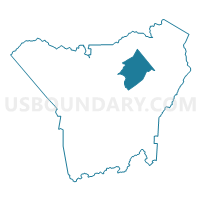
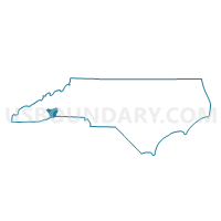
Voting District CC, Henderson County, North Carolina
About
Outline

Summary
| Unique Area Identifier | 640435 |
| Name | Voting District CC |
| County | Henderson County |
| State | North Carolina |
| Area (square miles) | 15.34 |
| Land Area (square miles) | 15.27 |
| Water Area (square miles) | 0.07 |
| % of Land Area | 99.52 |
| % of Water Area | 0.48 |
| Latitude of the Internal Point | 35.39773260 |
| Longtitude of the Internal Point | -82.41749720 |
Maps

Graphs
Select a template below for downloading or customizing gragh for Voting District CC, Henderson County, North Carolina


Neighbors
Neighoring Voting District (by Name) Neighboring Voting District on the Map
- Voting District ED, Henderson County, NC
- Voting District GM, Henderson County, NC
- Voting District HC, Henderson County, NC
- Voting District MG, Henderson County, NC
- Voting District NB, Henderson County, NC
- Voting District NE, Henderson County, NC
- Voting District PR, Henderson County, NC
Top 10 Neighboring County Subdivision (by Population) Neighboring County Subdivision on the Map
- Hendersonville township, Henderson County, NC (47,527)
- Hoopers Creek township, Henderson County, NC (14,573)
- Blue Ridge township, Henderson County, NC (11,172)
- Clear Creek township, Henderson County, NC (6,011)
- Edneyville township, Henderson County, NC (4,734)
Top 10 Neighboring Place (by Population) Neighboring Place on the Map
- Hendersonville city, NC (13,137)
- Edneyville CDP, NC (2,367)
- Fruitland CDP, NC (2,031)
- Hoopers Creek CDP, NC (1,056)
Top 10 Neighboring Unified School District (by Population) Neighboring Unified School District on the Map
Top 10 Neighboring State Legislative District Lower Chamber (by Population) Neighboring State Legislative District Lower Chamber on the Map
Top 10 Neighboring State Legislative District Upper Chamber (by Population) Neighboring State Legislative District Upper Chamber on the Map
Top 10 Neighboring 111th Congressional District (by Population) Neighboring 111th Congressional District on the Map
Top 10 Neighboring Census Tract (by Population) Neighboring Census Tract on the Map
- Census Tract 9303, Henderson County, NC (6,408)
- Census Tract 9310, Henderson County, NC (5,532)
- Census Tract 9305.02, Henderson County, NC (4,614)
- Census Tract 9301, Henderson County, NC (4,484)
- Census Tract 9304.01, Henderson County, NC (2,697)
- Census Tract 9304.02, Henderson County, NC (2,596)