


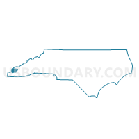
Voting District WEST, Graham County, North Carolina
About
Outline

Summary
| Unique Area Identifier | 640176 |
| Name | Voting District WEST |
| County | Graham County |
| State | North Carolina |
| Area (square miles) | 113.76 |
| Land Area (square miles) | 109.54 |
| Water Area (square miles) | 4.22 |
| % of Land Area | 96.29 |
| % of Water Area | 3.71 |
| Latitude of the Internal Point | 35.30592930 |
| Longtitude of the Internal Point | -83.91274610 |
Maps


Graphs
Select a template below for downloading or customizing gragh for Voting District WEST, Graham County, North Carolina


Neighbors
Neighoring Voting District (by Name) Neighboring Voting District on the Map
- 11 Tellico Community Center Voting District, Monroe County, TN
- Voting District ANNW, Cherokee County, NC
- Voting District EAST, Graham County, NC
- Voting District HANG, Cherokee County, NC
- Voting District MARB, Cherokee County, NC
- Voting District TAPO, Graham County, NC
Top 10 Neighboring County Subdivision (by Population) Neighboring County Subdivision on the Map
- District 3, Monroe County, TN (13,442)
- Murphy township, Cherokee County, NC (10,921)
- Valleytown township, Cherokee County, NC (7,275)
- Cheoah township, Graham County, NC (6,794)
- Beaverdam township, Cherokee County, NC (797)
- Yellow Creek township, Graham County, NC (642)
Top 10 Neighboring Place (by Population) Neighboring Place on the Map
Top 10 Neighboring Unified School District (by Population) Neighboring Unified School District on the Map
- Monroe County School District, TN (32,521)
- Cherokee County Schools, NC (27,444)
- Graham County Schools, NC (8,861)
Top 10 Neighboring State Legislative District Lower Chamber (by Population) Neighboring State Legislative District Lower Chamber on the Map
Top 10 Neighboring State Legislative District Upper Chamber (by Population) Neighboring State Legislative District Upper Chamber on the Map
Top 10 Neighboring 111th Congressional District (by Population) Neighboring 111th Congressional District on the Map
Top 10 Neighboring Census Tract (by Population) Neighboring Census Tract on the Map
- Census Tract 9255.02, Monroe County, TN (5,283)
- Census Tract 9301, Cherokee County, NC (4,571)
- Census Tract 9203, Graham County, NC (3,795)
- Census Tract 9255.01, Monroe County, TN (3,046)
- Census Tract 9202, Graham County, NC (2,869)
- Census Tract 9303, Cherokee County, NC (2,439)
- Census Tract 9302, Cherokee County, NC (2,410)
- Census Tract 9201, Graham County, NC (2,197)
Top 10 Neighboring 5-Digit ZIP Code Tabulation Area (by Population) Neighboring 5-Digit ZIP Code Tabulation Area on the Map
- 28906, NC (18,475)
- 28771, NC (8,558)
- 37385, TN (8,131)
- 28901, NC (5,354)
- 37885, TN (5,067)
- 28905, NC (3,129)