


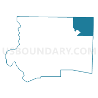
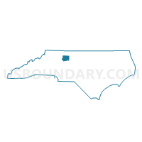
Voting District 021, Forsyth County, North Carolina
About
Outline

Summary
| Unique Area Identifier | 640068 |
| Name | Voting District 021 |
| County | Forsyth County |
| State | North Carolina |
| Area (square miles) | 30.38 |
| Land Area (square miles) | 29.38 |
| Water Area (square miles) | 1.00 |
| % of Land Area | 96.70 |
| % of Water Area | 3.30 |
| Latitude of the Internal Point | 36.22142170 |
| Longtitude of the Internal Point | -80.08140460 |
Maps

Graphs
Select a template below for downloading or customizing gragh for Voting District 021, Forsyth County, North Carolina


Neighbors
Neighoring Voting District (by Name) Neighboring Voting District on the Map
- Voting District 066, Forsyth County, NC
- Voting District 068, Forsyth County, NC
- Voting District 112, Forsyth County, NC
- Voting District 16, Stokes County, NC
- Voting District 18, Stokes County, NC
- Voting District HU, Rockingham County, NC
- Voting District OR1, Guilford County, NC
- Voting District STOK, Guilford County, NC
Top 10 Neighboring County Subdivision (by Population) Neighboring County Subdivision on the Map
- Kernersville township, Forsyth County, NC (30,386)
- Oak Ridge township, Guilford County, NC (11,402)
- Salem Chapel township, Forsyth County, NC (6,808)
- Belews Creek township, Forsyth County, NC (6,160)
- Huntsville township, Rockingham County, NC (6,085)
- Sauratown township, Stokes County, NC (5,681)
Top 10 Neighboring Place (by Population) Neighboring Place on the Map
Top 10 Neighboring Unified School District (by Population) Neighboring Unified School District on the Map
- Guilford County Schools, NC (488,406)
- Forsyth County Schools, NC (350,670)
- Rockingham County Schools, NC (93,643)
- Stokes County Schools, NC (47,401)
Top 10 Neighboring State Legislative District Lower Chamber (by Population) Neighboring State Legislative District Lower Chamber on the Map
- State House District 62, NC (90,023)
- State House District 73, NC (82,874)
- State House District 91, NC (74,449)
- State House District 74, NC (67,946)
Top 10 Neighboring State Legislative District Upper Chamber (by Population) Neighboring State Legislative District Upper Chamber on the Map
- State Senate District 26, NC (196,857)
- State Senate District 31, NC (175,229)
- State Senate District 30, NC (170,635)
Top 10 Neighboring 111th Congressional District (by Population) Neighboring 111th Congressional District on the Map
Top 10 Neighboring Census Tract (by Population) Neighboring Census Tract on the Map
- Census Tract 410.01, Rockingham County, NC (6,103)
- Census Tract 707, Stokes County, NC (5,681)
- Census Tract 31.03, Forsyth County, NC (5,468)
- Census Tract 159.01, Guilford County, NC (5,270)
- Census Tract 31.05, Forsyth County, NC (3,649)
- Census Tract 159.02, Guilford County, NC (3,611)
- Census Tract 31.08, Forsyth County, NC (3,495)
- Census Tract 31.06, Forsyth County, NC (3,099)