


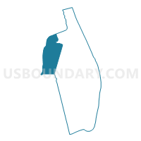
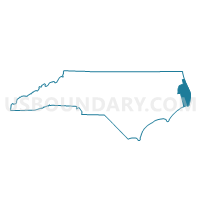
Voting District EL, Dare County, North Carolina
About
Outline

Summary
| Unique Area Identifier | 639839 |
| Name | Voting District EL |
| County | Dare County |
| State | North Carolina |
| Area (square miles) | 194.57 |
| Land Area (square miles) | 132.83 |
| Water Area (square miles) | 61.74 |
| % of Land Area | 68.27 |
| % of Water Area | 31.73 |
| Latitude of the Internal Point | 35.81726010 |
| Longtitude of the Internal Point | -75.92775950 |
Maps

Graphs
Select a template below for downloading or customizing gragh for Voting District EL, Dare County, North Carolina


Neighbors
Neighoring Voting District (by Name) Neighboring Voting District on the Map
- Voting District 01, Tyrrell County, NC
- Voting District 03, Tyrrell County, NC
- Voting District ENG, Hyde County, NC
- Voting District MH, Dare County, NC
- Voting District STPT, Dare County, NC
Top 10 Neighboring County Subdivision (by Population) Neighboring County Subdivision on the Map
- Lake Landing township, Hyde County, NC (1,784)
- Croatan township, Dare County, NC (1,085)
- Gum Neck township, Tyrrell County, NC (425)
- Alligator township, Tyrrell County, NC (330)
- East Lake township, Dare County, NC (161)
Top 10 Neighboring Unified School District (by Population) Neighboring Unified School District on the Map
Top 10 Neighboring State Legislative District Lower Chamber (by Population) Neighboring State Legislative District Lower Chamber on the Map
Top 10 Neighboring State Legislative District Upper Chamber (by Population) Neighboring State Legislative District Upper Chamber on the Map
Top 10 Neighboring 111th Congressional District (by Population) Neighboring 111th Congressional District on the Map
Top 10 Neighboring Census Tract (by Population) Neighboring Census Tract on the Map
- Census Tract 9201, Hyde County, NC (5,810)
- Census Tract 9601, Tyrrell County, NC (4,407)
- Census Tract 9705.01, Dare County, NC (1,246)