


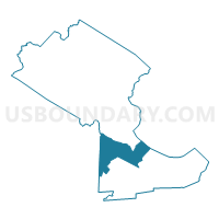
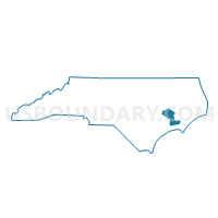
Voting District 17, Craven County, North Carolina
About
Outline

Summary
| Unique Area Identifier | 639769 |
| Name | Voting District 17 |
| County | Craven County |
| State | North Carolina |
| Area (square miles) | 53.69 |
| Land Area (square miles) | 48.17 |
| Water Area (square miles) | 5.52 |
| % of Land Area | 89.73 |
| % of Water Area | 10.27 |
| Latitude of the Internal Point | 34.96352520 |
| Longtitude of the Internal Point | -77.02483570 |
Maps

Graphs
Select a template below for downloading or customizing gragh for Voting District 17, Craven County, North Carolina


Neighbors
Neighoring Voting District (by Name) Neighboring Voting District on the Map
- Voting District 16, Craven County, NC
- Voting District 21, Craven County, NC
- Voting District 22, Craven County, NC
- Voting District 23, Craven County, NC
- Voting District 5AP, Pamlico County, NC
- Voting District P04, Jones County, NC
- Voting District P07, Jones County, NC
Top 10 Neighboring County Subdivision (by Population) Neighboring County Subdivision on the Map
- Township 6, Craven County, NC (25,398)
- Township 7, Craven County, NC (14,197)
- Township 5, Pamlico County, NC (2,724)
- Township 2, Pollocksville, Jones County, NC (2,612)
- Township 1, White Oak, Jones County, NC (2,038)
Top 10 Neighboring Place (by Population) Neighboring Place on the Map
- New Bern city, NC (29,524)
- Havelock city, NC (20,735)
- Brices Creek CDP, NC (3,073)
- Neuse Forest CDP, NC (2,005)
Top 10 Neighboring Unified School District (by Population) Neighboring Unified School District on the Map
- Craven County Schools, NC (103,505)
- Pamlico County Schools, NC (13,144)
- Jones County Schools, NC (10,153)
Top 10 Neighboring State Legislative District Lower Chamber (by Population) Neighboring State Legislative District Lower Chamber on the Map
- State House District 13, NC (76,622)
- State House District 3, NC (73,905)
- State House District 12, NC (63,600)
Top 10 Neighboring State Legislative District Upper Chamber (by Population) Neighboring State Legislative District Upper Chamber on the Map
Top 10 Neighboring 111th Congressional District (by Population) Neighboring 111th Congressional District on the Map
Top 10 Neighboring Census Tract (by Population) Neighboring Census Tract on the Map
- Census Tract 9610.01, Craven County, NC (9,336)
- Census Tract 9611, Craven County, NC (8,979)
- Census Tract 9612.01, Craven County, NC (4,095)
- Census Tract 9201, Jones County, NC (3,888)
- Census Tract 9501.01, Pamlico County, NC (2,941)
Top 10 Neighboring 5-Digit ZIP Code Tabulation Area (by Population) Neighboring 5-Digit ZIP Code Tabulation Area on the Map
- 28562, NC (36,176)
- 28560, NC (28,921)
- 28532, NC (23,320)
- 28555, NC (5,175)
- 28529, NC (2,193)
- 28573, NC (2,176)