


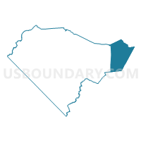
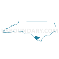
Voting District P14, Columbus County, North Carolina
About
Outline

Summary
| Unique Area Identifier | 639746 |
| Name | Voting District P14 |
| County | Columbus County |
| State | North Carolina |
| Area (square miles) | 80.24 |
| Land Area (square miles) | 79.69 |
| Water Area (square miles) | 0.55 |
| % of Land Area | 99.31 |
| % of Water Area | 0.69 |
| Latitude of the Internal Point | 34.30458970 |
| Longtitude of the Internal Point | -78.27841920 |
Maps

Graphs
Select a template below for downloading or customizing gragh for Voting District P14, Columbus County, North Carolina


Neighbors
Neighoring Voting District (by Name) Neighboring Voting District on the Map
- Voting District 01, Brunswick County, NC
- Voting District 05, Brunswick County, NC
- Voting District 11, Brunswick County, NC
- Voting District 18, Brunswick County, NC
- Voting District CT03, Pender County, NC
- Voting District P02, Columbus County, NC
- Voting District P30, Bladen County, NC
- Voting District P55, Bladen County, NC
Top 10 Neighboring County Subdivision (by Population) Neighboring County Subdivision on the Map
- Lockwoods Folly township, Brunswick County, NC (23,248)
- Northwest township, Brunswick County, NC (12,190)
- Ransom township, Columbus County, NC (4,809)
- Waccamaw township, Brunswick County, NC (3,448)
- Carvers Creek township, Bladen County, NC (1,884)
- Bolton township, Columbus County, NC (1,611)
- Frenches Creek township, Bladen County, NC (1,035)
- Canetuck township, Pender County, NC (370)
Top 10 Neighboring Place (by Population) Neighboring Place on the Map
- Northwest city, NC (735)
- Riegelwood CDP, NC (579)
- East Arcadia town, NC (487)
- Sandyfield town, NC (447)
- Delco CDP, NC (348)
Top 10 Neighboring Unified School District (by Population) Neighboring Unified School District on the Map
- Brunswick County Schools, NC (107,431)
- Pender County Schools, NC (52,217)
- Columbus County Schools, NC (43,225)
- Bladen County Schools, NC (35,190)
Top 10 Neighboring State Legislative District Lower Chamber (by Population) Neighboring State Legislative District Lower Chamber on the Map
- State House District 17, NC (94,557)
- State House District 16, NC (93,684)
- State House District 22, NC (83,941)
- State House District 20, NC (70,972)
Top 10 Neighboring State Legislative District Upper Chamber (by Population) Neighboring State Legislative District Upper Chamber on the Map
Top 10 Neighboring 111th Congressional District (by Population) Neighboring 111th Congressional District on the Map
Top 10 Neighboring Census Tract (by Population) Neighboring Census Tract on the Map
- Census Tract 9506, Bladen County, NC (6,453)
- Census Tract 9501, Bladen County, NC (5,693)
- Census Tract 206.02, Brunswick County, NC (5,147)
- Census Tract 9301, Columbus County, NC (4,198)
- Census Tract 201.01, Brunswick County, NC (2,706)
- Census Tract 9302, Columbus County, NC (2,175)
- Census Tract 9205.02, Pender County, NC (1,717)
Top 10 Neighboring 5-Digit ZIP Code Tabulation Area (by Population) Neighboring 5-Digit ZIP Code Tabulation Area on the Map
- 28451, NC (27,112)
- 28420, NC (3,886)
- 28456, NC (3,658)
- 28435, NC (2,490)
- 28423, NC (2,290)
- 28436, NC (2,203)
- 28448, NC (1,243)