


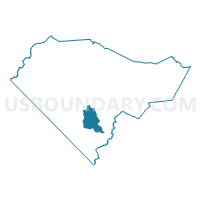
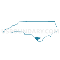
Voting District P13, Columbus County, North Carolina
About
Outline

Summary
| Unique Area Identifier | 639734 |
| Name | Voting District P13 |
| County | Columbus County |
| State | North Carolina |
| Area (square miles) | 24.62 |
| Land Area (square miles) | 24.59 |
| Water Area (square miles) | 0.04 |
| % of Land Area | 99.85 |
| % of Water Area | 0.15 |
| Latitude of the Internal Point | 34.13428660 |
| Longtitude of the Internal Point | -78.66442230 |
Maps

Graphs
Select a template below for downloading or customizing gragh for Voting District P13, Columbus County, North Carolina


Neighbors
Neighoring Voting District (by Name) Neighboring Voting District on the Map
- Voting District P05, Columbus County, NC
- Voting District P10, Columbus County, NC
- Voting District P11, Columbus County, NC
- Voting District P25, Columbus County, NC
Top 10 Neighboring County Subdivision (by Population) Neighboring County Subdivision on the Map
- Williams township, Columbus County, NC (4,578)
- Lees township, Columbus County, NC (3,835)
- Bug Hill township, Columbus County, NC (2,892)