


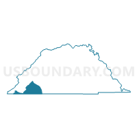
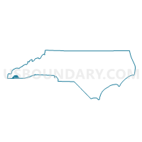
Voting District WARN, Clay County, North Carolina
About
Outline

Summary
| Unique Area Identifier | 639688 |
| Name | Voting District WARN |
| County | Clay County |
| State | North Carolina |
| Area (square miles) | 9.16 |
| Land Area (square miles) | 9.16 |
| Water Area (square miles) | 0.00 |
| % of Land Area | 100.00 |
| % of Water Area | 0.00 |
| Latitude of the Internal Point | 35.00219680 |
| Longtitude of the Internal Point | -83.90138470 |
Maps

Graphs
Select a template below for downloading or customizing gragh for Voting District WARN, Clay County, North Carolina


Neighbors
Neighoring Voting District (by Name) Neighboring Voting District on the Map
- 2811468 - YOUNG HARRIS Voting District, Towns County, GA
- 2914 - IVY LOG Voting District, Union County, GA
- 2918 - GUMLOG Voting District, Union County, GA
- Voting District BRAS, Clay County, NC
- Voting District HAY2, Clay County, NC
- Voting District SWEE, Clay County, NC
Top 10 Neighboring County Subdivision (by Population) Neighboring County Subdivision on the Map
- Ivylog CCD, Union County, GA (7,781)
- Young Harris CCD, Towns County, GA (4,027)
- Hayesville township, Clay County, NC (3,868)
- Brasstown township, Clay County, NC (2,014)
- Sweetwater township, Clay County, NC (850)
Top 10 Neighboring Unified School District (by Population) Neighboring Unified School District on the Map
- Union County School District, GA (21,356)
- Clay County Schools, NC (10,587)
- Towns County School District, GA (10,471)
Top 10 Neighboring State Legislative District Lower Chamber (by Population) Neighboring State Legislative District Lower Chamber on the Map
Top 10 Neighboring State Legislative District Upper Chamber (by Population) Neighboring State Legislative District Upper Chamber on the Map
- State Senate District 51, GA (190,842)
- State Senate District 50, NC (175,858)
- State Senate District 50, GA (164,656)
Top 10 Neighboring 111th Congressional District (by Population) Neighboring 111th Congressional District on the Map
- Congressional District 9, GA (823,583)
- Congressional District 10, GA (738,248)
- Congressional District 11, NC (703,606)
Top 10 Neighboring Census Tract (by Population) Neighboring Census Tract on the Map
- Census Tract 9502, Clay County, NC (5,525)
- Census Tract 1.02, Union County, GA (5,088)
- Census Tract 9601, Towns County, GA (4,027)