


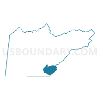
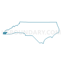
Voting District BRAS, Cherokee County, North Carolina
About
Outline

Summary
| Unique Area Identifier | 639680 |
| Name | Voting District BRAS |
| County | Cherokee County |
| State | North Carolina |
| Area (square miles) | 14.04 |
| Land Area (square miles) | 14.04 |
| Water Area (square miles) | 0.00 |
| % of Land Area | 100.00 |
| % of Water Area | 0.00 |
| Latitude of the Internal Point | 35.02384900 |
| Longtitude of the Internal Point | -84.00499020 |
Maps

Graphs
Select a template below for downloading or customizing gragh for Voting District BRAS, Cherokee County, North Carolina


Neighbors
Neighoring Voting District (by Name) Neighboring Voting District on the Map
- Voting District BELL, Cherokee County, NC
- Voting District BRAS, Clay County, NC
- Voting District MURS, Cherokee County, NC
Top 10 Neighboring County Subdivision (by Population) Neighboring County Subdivision on the Map
- Murphy township, Cherokee County, NC (10,921)
- Notla township, Cherokee County, NC (4,570)
- Brasstown township, Clay County, NC (2,014)