


Voting District 02, Catawba County, North Carolina
About
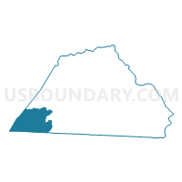
Outline

Summary
| Unique Area Identifier | 639613 |
| Name | Voting District 02 |
| County | Catawba County |
| State | North Carolina |
| Area (square miles) | 32.51 |
| Land Area (square miles) | 32.32 |
| Water Area (square miles) | 0.19 |
| % of Land Area | 99.43 |
| % of Water Area | 0.57 |
| Latitude of the Internal Point | 35.61050240 |
| Longtitude of the Internal Point | -81.44374330 |
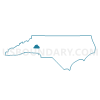
Maps

Graphs
Select a template below for downloading or customizing gragh for Voting District 02, Catawba County, North Carolina


Neighbors
Neighoring Voting District (by Name) Neighboring Voting District on the Map
- Voting District 0012, Burke County, NC
- Voting District 0029, Burke County, NC
- Voting District 03, Catawba County, NC
- Voting District 24, Catawba County, NC
- Voting District DV08, Lincoln County, NC
- Voting District NB03, Lincoln County, NC
Top 10 Neighboring County Subdivision (by Population) Neighboring County Subdivision on the Map
- Icard township, Burke County, NC (17,628)
- Howards Creek township, Lincoln County, NC (8,988)
- North Brook township, Lincoln County, NC (5,840)
- Jacobs Fork township, Catawba County, NC (5,157)
- Bandy's township, Catawba County, NC (4,864)
- Lower Fork township, Burke County, NC (3,667)
Top 10 Neighboring Unified School District (by Population) Neighboring Unified School District on the Map
- Catawba County Schools, NC (104,773)
- Burke County Schools, NC (90,912)
- Lincoln County Schools, NC (78,265)
Top 10 Neighboring State Legislative District Lower Chamber (by Population) Neighboring State Legislative District Lower Chamber on the Map
- State House District 97, NC (78,265)
- State House District 96, NC (72,247)
- State House District 85, NC (71,855)
Top 10 Neighboring State Legislative District Upper Chamber (by Population) Neighboring State Legislative District Upper Chamber on the Map
- State Senate District 41, NC (207,713)
- State Senate District 42, NC (184,148)
- State Senate District 44, NC (173,941)
Top 10 Neighboring 111th Congressional District (by Population) Neighboring 111th Congressional District on the Map
Top 10 Neighboring Census Tract (by Population) Neighboring Census Tract on the Map
- Census Tract 118.01, Catawba County, NC (6,218)
- Census Tract 118.02, Catawba County, NC (5,952)
- Census Tract 706, Lincoln County, NC (4,585)
- Census Tract 212.03, Burke County, NC (4,409)