


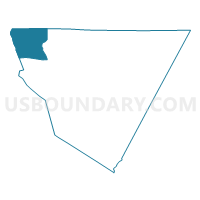
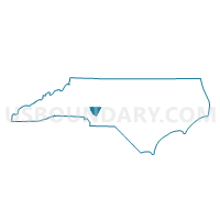
Voting District 03-00, Cabarrus County, North Carolina
About
Outline

Summary
| Unique Area Identifier | 639527 |
| Name | Voting District 03-00 |
| County | Cabarrus County |
| State | North Carolina |
| Area (square miles) | 21.89 |
| Land Area (square miles) | 20.02 |
| Water Area (square miles) | 1.86 |
| % of Land Area | 91.49 |
| % of Water Area | 8.51 |
| Latitude of the Internal Point | 35.47268240 |
| Longtitude of the Internal Point | -80.73500220 |
Maps

Graphs
Select a template below for downloading or customizing gragh for Voting District 03-00, Cabarrus County, North Carolina


Neighbors
Neighoring Voting District (by Name) Neighboring Voting District on the Map
- Voting District 02-08, Cabarrus County, NC
- Voting District 04-08, Cabarrus County, NC
- Voting District 04-09, Cabarrus County, NC
- Voting District 127, Mecklenburg County, NC
- Voting District 202, Mecklenburg County, NC
- Voting District 44, Rowan County, NC
- Voting District CC1, Iredell County, NC
- Voting District CC3, Iredell County, NC
- Voting District CC4, Iredell County, NC
Top 10 Neighboring County Subdivision (by Population) Neighboring County Subdivision on the Map
- Township 4, Kannapolis, Cabarrus County, NC (42,072)
- Coddle Creek township, Iredell County, NC (32,599)
- Township 15, Huntersville, Mecklenburg County, NC (28,977)
- Township 9, Deweese, Mecklenburg County, NC (21,932)
- Atwell township, Rowan County, NC (12,428)
- Township 3, Odell, Cabarrus County, NC (12,348)
Top 10 Neighboring Place (by Population) Neighboring Place on the Map
- Concord city, NC (79,066)
- Kannapolis city, NC (42,625)
- Davidson town, NC (10,944)
- Enochville CDP, NC (2,925)
Top 10 Neighboring Unified School District (by Population) Neighboring Unified School District on the Map
- Charlotte-Mecklenburg Schools, NC (919,628)
- Cabarrus County Schools, NC (155,489)
- Iredell-Statesville Schools, NC (131,920)
- Rowan-Salisbury Schools, NC (130,380)
- Mooresville City Schools, NC (27,517)
Top 10 Neighboring State Legislative District Lower Chamber (by Population) Neighboring State Legislative District Lower Chamber on the Map
- State House District 98, NC (125,672)
- State House District 95, NC (94,835)
- State House District 82, NC (93,684)
- State House District 83, NC (84,327)
- State House District 76, NC (71,116)
Top 10 Neighboring State Legislative District Upper Chamber (by Population) Neighboring State Legislative District Upper Chamber on the Map
- State Senate District 40, NC (245,233)
- State Senate District 36, NC (210,610)
- State Senate District 34, NC (179,668)
Top 10 Neighboring 111th Congressional District (by Population) Neighboring 111th Congressional District on the Map
- Congressional District 9, NC (852,377)
- Congressional District 12, NC (736,346)
- Congressional District 8, NC (709,449)
- Congressional District 10, NC (689,468)
Top 10 Neighboring Census Tract (by Population) Neighboring Census Tract on the Map
- Census Tract 413.02, Cabarrus County, NC (7,567)
- Census Tract 63.04, Mecklenburg County, NC (6,045)
- Census Tract 412, Cabarrus County, NC (5,779)
- Census Tract 64.04, Mecklenburg County, NC (4,952)
- Census Tract 518.01, Rowan County, NC (4,148)
- Census Tract 413.01, Cabarrus County, NC (3,738)
- Census Tract 614.08, Iredell County, NC (3,541)
- Census Tract 515.02, Rowan County, NC (3,220)