


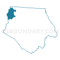
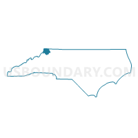
Voting District 18, Ashe County, North Carolina
About
Outline

Summary
| Unique Area Identifier | 639294 |
| Name | Voting District 18 |
| County | Ashe County |
| State | North Carolina |
| Area (square miles) | 16.72 |
| Land Area (square miles) | 16.70 |
| Water Area (square miles) | 0.02 |
| % of Land Area | 99.85 |
| % of Water Area | 0.15 |
| Latitude of the Internal Point | 36.54056990 |
| Longtitude of the Internal Point | -81.65531250 |
Maps

Graphs
Select a template below for downloading or customizing gragh for Voting District 18, Ashe County, North Carolina


Neighbors
Neighoring Voting District (by Name) Neighboring Voting District on the Map
- Voting District 02, Ashe County, NC
- Voting District 07, Ashe County, NC
- Voting District 08, Ashe County, NC
- Voting District 10, Ashe County, NC
- 1A Laurel Voting District, Johnson County, TN
- 2 Forge/Shouns Voting District, Johnson County, TN
Top 10 Neighboring County Subdivision (by Population) Neighboring County Subdivision on the Map
- District 1, Johnson County, TN (3,425)
- Clifton township, Ashe County, NC (1,911)
- District 2, Johnson County, TN (1,192)
- Horse Creek township, Ashe County, NC (680)
- Laurel township, Ashe County, NC (413)
- Hurricane township, Ashe County, NC (302)
- Pond Mountain township, Ashe County, NC (240)