


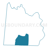
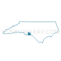
Voting District GULL, Anson County, North Carolina
About
Outline

Summary
| Unique Area Identifier | 639283 |
| Name | Voting District GULL |
| County | Anson County |
| State | North Carolina |
| Area (square miles) | 51.84 |
| Land Area (square miles) | 51.75 |
| Water Area (square miles) | 0.08 |
| % of Land Area | 99.84 |
| % of Water Area | 0.16 |
| Latitude of the Internal Point | 34.85736790 |
| Longtitude of the Internal Point | -80.11915670 |
Maps

Graphs
Select a template below for downloading or customizing gragh for Voting District GULL, Anson County, North Carolina


Neighbors
Neighoring Voting District (by Name) Neighboring Voting District on the Map
- Voting District LILE, Anson County, NC
- Voting District MM, Anson County, NC
- Mt. Croghan Voting District, Chesterfield County, SC
- Ruby Voting District, Chesterfield County, SC
- Snow Hill-Vaughn Voting District, Chesterfield County, SC
- Voting District W2, Anson County, NC
- Voting District W3, Anson County, NC
- Voting District WS, Anson County, NC
Top 10 Neighboring County Subdivision (by Population) Neighboring County Subdivision on the Map
- Wadesboro township, Anson County, NC (9,118)
- Chesterfield CCD, Chesterfield County, SC (7,275)
- Mount Croghan CCD, Chesterfield County, SC (2,821)
- Gulledge township, Anson County, NC (2,238)
- Morven township, Anson County, NC (2,065)
- White Store township, Anson County, NC (506)
Top 10 Neighboring Unified School District (by Population) Neighboring Unified School District on the Map
Top 10 Neighboring State Legislative District Lower Chamber (by Population) Neighboring State Legislative District Lower Chamber on the Map
- State House District 69, NC (77,122)
- State House District 53, SC (34,472)
- State House District 54, SC (32,159)
Top 10 Neighboring State Legislative District Upper Chamber (by Population) Neighboring State Legislative District Upper Chamber on the Map
Top 10 Neighboring 111th Congressional District (by Population) Neighboring 111th Congressional District on the Map
Top 10 Neighboring Census Tract (by Population) Neighboring Census Tract on the Map
- Census Tract 9504, Chesterfield County, SC (7,275)
- Census Tract 9205, Anson County, NC (6,138)
- Census Tract 9206, Anson County, NC (4,451)
- Census Tract 9503, Chesterfield County, SC (2,821)