


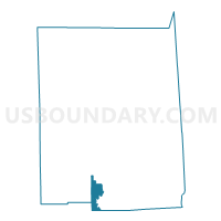
Voting District 010010, Wayne County, New York
About
Outline

Summary
| Unique Area Identifier | 638246 |
| Name | Voting District 010010 |
| County | Wayne County |
| State | New York |
| Area (square miles) | 12.54 |
| Land Area (square miles) | 12.48 |
| Water Area (square miles) | 0.06 |
| % of Land Area | 99.52 |
| % of Water Area | 0.48 |
| Latitude of the Internal Point | 43.07339100 |
| Longtitude of the Internal Point | -77.12118950 |
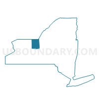
Maps

Graphs
Select a template below for downloading or customizing gragh for Voting District 010010, Wayne County, New York


Neighbors
Neighoring Voting District (by Name) Neighboring Voting District on the Map
- Voting District 010001, Wayne County, NY
- Voting District 010002, Wayne County, NY
- Voting District 010005, Wayne County, NY
- Voting District 010006, Wayne County, NY
- Voting District 010008, Wayne County, NY
- Voting District 010009, Wayne County, NY
- Voting District 070004, Wayne County, NY
- Voting District 090005, Wayne County, NY
- Voting District 090006, Wayne County, NY
- Voting District 110003, Ontario County, NY
- Voting District 130004, Ontario County, NY
- Voting District 130006, Ontario County, NY
Top 10 Neighboring County Subdivision (by Population) Neighboring County Subdivision on the Map
- Arcadia town, Wayne County, NY (14,244)
- Manchester town, Ontario County, NY (9,395)
- Palmyra town, Wayne County, NY (7,975)
- Phelps town, Ontario County, NY (7,072)
- Marion town, Wayne County, NY (4,746)
Top 10 Neighboring Place (by Population) Neighboring Place on the Map
Top 10 Neighboring Unified School District (by Population) Neighboring Unified School District on the Map
- Newark Central School District, NY (15,174)
- Phelps-Clifton Springs Central School District, NY (11,506)
- Marion Central School District, NY (5,699)
Top 10 Neighboring State Legislative District Lower Chamber (by Population) Neighboring State Legislative District Lower Chamber on the Map
Top 10 Neighboring State Legislative District Upper Chamber (by Population) Neighboring State Legislative District Upper Chamber on the Map
Top 10 Neighboring 111th Congressional District (by Population) Neighboring 111th Congressional District on the Map
Top 10 Neighboring Census Tract (by Population) Neighboring Census Tract on the Map
- Census Tract 504, Ontario County, NY (7,072)
- Census Tract 210, Wayne County, NY (6,470)
- Census Tract 211, Wayne County, NY (5,193)
- Census Tract 205, Wayne County, NY (4,746)
- Census Tract 212, Wayne County, NY (4,644)
- Census Tract 503.01, Ontario County, NY (4,605)
- Census Tract 206, Wayne County, NY (4,258)