


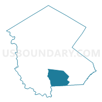
Voting District 060001, Sullivan County, New York
About
Outline

Summary
| Unique Area Identifier | 637882 |
| Name | Voting District 060001 |
| County | Sullivan County |
| State | New York |
| Area (square miles) | 56.31 |
| Land Area (square miles) | 54.78 |
| Water Area (square miles) | 1.53 |
| % of Land Area | 97.28 |
| % of Water Area | 2.72 |
| Latitude of the Internal Point | 41.56180240 |
| Longtitude of the Internal Point | -74.70961810 |
Maps


Graphs
Select a template below for downloading or customizing gragh for Voting District 060001, Sullivan County, New York


Neighbors
Neighoring Voting District (by Name) Neighboring Voting District on the Map
- Voting District 010004, Sullivan County, NY
- Voting District 050005, Orange County, NY
- Voting District 050006, Orange County, NY
- Voting District 100001, Sullivan County, NY
- Voting District 110004, Sullivan County, NY
- Voting District 140001, Sullivan County, NY
- Voting District 140005 140006 140010, Sullivan County, NY
Top 10 Neighboring County Subdivision (by Population) Neighboring County Subdivision on the Map
- Thompson town, Sullivan County, NY (15,308)
- Mamakating town, Sullivan County, NY (12,085)
- Deerpark town, Orange County, NY (7,901)
- Bethel town, Sullivan County, NY (4,255)
- Lumberland town, Sullivan County, NY (2,468)
- Forestburgh town, Sullivan County, NY (819)
Top 10 Neighboring Unified School District (by Population) Neighboring Unified School District on the Map
- Monticello Central School District, NY (21,934)
- Port Jervis City School District, NY (17,498)
- Eldred Central School District, NY (5,156)
Top 10 Neighboring State Legislative District Lower Chamber (by Population) Neighboring State Legislative District Lower Chamber on the Map
Top 10 Neighboring State Legislative District Upper Chamber (by Population) Neighboring State Legislative District Upper Chamber on the Map
Top 10 Neighboring 111th Congressional District (by Population) Neighboring 111th Congressional District on the Map
Top 10 Neighboring Census Tract (by Population) Neighboring Census Tract on the Map
- Census Tract 9513, Sullivan County, NY (4,410)
- Census Tract 9517, Sullivan County, NY (4,227)
- Census Tract 116.02, Orange County, NY (3,732)
- Census Tract 9516, Sullivan County, NY (3,152)
- Census Tract 9525, Sullivan County, NY (2,468)
- Census Tract 9520, Sullivan County, NY (2,399)
Top 10 Neighboring 5-Digit ZIP Code Tabulation Area (by Population) Neighboring 5-Digit ZIP Code Tabulation Area on the Map
- 12701, NY (11,324)
- 12790, NY (4,518)
- 12780, NY (2,312)
- 12775, NY (2,297)
- 12737, NY (1,910)
- 12729, NY (1,874)
- 12785, NY (1,024)
- 12746, NY (937)
- 12777, NY (764)
- 12762, NY (512)