


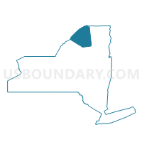
Voting District 010001, St. Lawrence County, New York
About
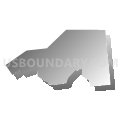
Outline

Summary
| Unique Area Identifier | 636310 |
| Name | Voting District 010001 |
| County | St. Lawrence County |
| State | New York |
| Area (square miles) | 50.03 |
| Land Area (square miles) | 49.43 |
| Water Area (square miles) | 0.60 |
| % of Land Area | 98.79 |
| % of Water Area | 1.21 |
| Latitude of the Internal Point | 44.90370210 |
| Longtitude of the Internal Point | -74.73253740 |
Maps


Graphs
Select a template below for downloading or customizing gragh for Voting District 010001, St. Lawrence County, New York


Neighbors
Neighoring Voting District (by Name) Neighboring Voting District on the Map
- Voting District 010002, St. Lawrence County, NY
- Voting District 040001, Franklin County, NY
- Voting District 040002, Franklin County, NY
- Voting District 160001, Franklin County, NY
- Voting District 200000, Franklin County, NY
- Voting District 200013, St. Lawrence County, NY
- Voting District 220004, St. Lawrence County, NY
Top 10 Neighboring County Subdivision (by Population) Neighboring County Subdivision on the Map
- Massena town, St. Lawrence County, NY (12,883)
- Norfolk town, St. Lawrence County, NY (4,668)
- St. Regis Mohawk Reservation, Franklin County, NY (3,228)
- Moira town, Franklin County, NY (2,934)
- Brasher town, St. Lawrence County, NY (2,512)
- Bombay town, Franklin County, NY (1,357)
Top 10 Neighboring Unified School District (by Population) Neighboring Unified School District on the Map
- Massena Central School District, NY (17,243)
- Salmon River Central School District, NY (7,455)
- Brasher Falls Central School District, NY (5,837)
- Brushton-Moira Central School District, NY (4,797)
Top 10 Neighboring State Legislative District Lower Chamber (by Population) Neighboring State Legislative District Lower Chamber on the Map
- Assembly District 114, NY (135,275)
- Assembly District 122, NY (131,778)
- Assembly District 118, NY (129,137)
Top 10 Neighboring State Legislative District Upper Chamber (by Population) Neighboring State Legislative District Upper Chamber on the Map
Top 10 Neighboring 111th Congressional District (by Population) Neighboring 111th Congressional District on the Map
Top 10 Neighboring Census Tract (by Population) Neighboring Census Tract on the Map
- Census Tract 4907, St. Lawrence County, NY (6,177)
- Census Tract 9503, Franklin County, NY (5,735)
- Census Tract 4903, St. Lawrence County, NY (5,667)
- Census Tract 9502, Franklin County, NY (4,852)
- Census Tract 4906, St. Lawrence County, NY (4,668)
- Census Tract 9400, Franklin County, NY (3,228)
Top 10 Neighboring 5-Digit ZIP Code Tabulation Area (by Population) Neighboring 5-Digit ZIP Code Tabulation Area on the Map
- 13662, NY (16,582)
- 13655, NY (3,512)
- 13667, NY (3,181)
- 13613, NY (2,726)
- 12957, NY (1,726)
- 12914, NY (1,044)