


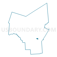
Voting District 150201, Oneida County, New York
About
Outline

Summary
| Unique Area Identifier | 632921 |
| Name | Voting District 150201 |
| County | Oneida County |
| State | New York |
| Area (square miles) | 1.08 |
| Land Area (square miles) | 1.08 |
| Water Area (square miles) | 0.00 |
| % of Land Area | 100.00 |
| % of Water Area | 0.00 |
| Latitude of the Internal Point | 43.09284160 |
| Longtitude of the Internal Point | -75.30281480 |
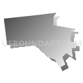
Maps


Graphs
Select a template below for downloading or customizing gragh for Voting District 150201, Oneida County, New York


Neighbors
Neighoring Voting District (by Name) Neighboring Voting District on the Map
- Voting District 150202, Oneida County, NY
- Voting District 150302, Oneida County, NY
- Voting District 150402, Oneida County, NY
- Voting District 150404, Oneida County, NY
- Voting District 220302, Oneida County, NY
- Voting District 280003, Oneida County, NY
- Voting District 280014, Oneida County, NY
- Voting District 280015, Oneida County, NY
Top 10 Neighboring County Subdivision (by Population) Neighboring County Subdivision on the Map
- Utica city, Oneida County, NY (62,235)
- New Hartford town, Oneida County, NY (22,166)
- Whitestown town, Oneida County, NY (18,667)
Top 10 Neighboring Place (by Population) Neighboring Place on the Map
Top 10 Neighboring Unified School District (by Population) Neighboring Unified School District on the Map
- Utica City School District, NY (62,275)
- Whitesboro Central School District, NY (26,133)
- New Hartford Central School District, NY (16,975)
- New York Mills Union Free School District, NY (5,549)
Top 10 Neighboring State Legislative District Lower Chamber (by Population) Neighboring State Legislative District Lower Chamber on the Map
Top 10 Neighboring State Legislative District Upper Chamber (by Population) Neighboring State Legislative District Upper Chamber on the Map
Top 10 Neighboring 111th Congressional District (by Population) Neighboring 111th Congressional District on the Map
Top 10 Neighboring Census Tract (by Population) Neighboring Census Tract on the Map
- Census Tract 253, Oneida County, NY (7,122)
- Census Tract 234, Oneida County, NY (4,876)
- Census Tract 235.02, Oneida County, NY (4,444)
- Census Tract 252, Oneida County, NY (4,367)
- Census Tract 217.02, Oneida County, NY (2,572)
- Census Tract 235.01, Oneida County, NY (2,302)