


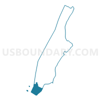
Voting District 6400002, New York County, New York
About
Outline

Summary
| Unique Area Identifier | 632272 |
| Name | Voting District 6400002 |
| County | New York County |
| State | New York |
| Area (square miles) | 1.84 |
| Land Area (square miles) | 0.45 |
| Water Area (square miles) | 1.39 |
| % of Land Area | 24.59 |
| % of Water Area | 75.41 |
| Latitude of the Internal Point | 40.69239290 |
| Longtitude of the Internal Point | -74.01857540 |
Maps

Graphs
Select a template below for downloading or customizing gragh for Voting District 6400002, New York County, New York


Neighbors
Neighoring Voting District (by Name) Neighboring Voting District on the Map
- Voting District 5100024, Kings County, NY
- Voting District 5200095 5200109, Kings County, NY
- Voting District 5200128, Kings County, NY
- Voting District 6400001, New York County, NY
- Voting District 6400003, New York County, NY
- Voting District 6400004, New York County, NY
- Voting District 6400005 6400006, New York County, NY
- Voting District 6400007, New York County, NY
- Jersey City city ward F voting district 1, Hudson County, NJ
- Jersey City city ward F voting district 31, Hudson County, NJ
Top 10 Neighboring County Subdivision (by Population) Neighboring County Subdivision on the Map
- Brooklyn borough, Kings County, NY (2,504,700)
- Manhattan borough, New York County, NY (1,585,873)
- Jersey City city, Hudson County, NJ (247,597)
Top 10 Neighboring Place (by Population) Neighboring Place on the Map
Top 10 Neighboring Unified School District (by Population) Neighboring Unified School District on the Map
Top 10 Neighboring State Legislative District Lower Chamber (by Population) Neighboring State Legislative District Lower Chamber on the Map
- General Assembly District 31, NJ (214,973)
- Assembly District 64, NY (136,671)
- Assembly District 51, NY (127,463)
- Assembly District 52, NY (124,831)
Top 10 Neighboring State Legislative District Upper Chamber (by Population) Neighboring State Legislative District Upper Chamber on the Map
- State Senate District 25, NY (335,683)
- State Senate District 18, NY (316,903)
- State Senate District 31, NJ (214,973)
Top 10 Neighboring 111th Congressional District (by Population) Neighboring 111th Congressional District on the Map
- Congressional District 8, NY (713,512)
- Congressional District 13, NJ (684,965)
- Congressional District 12, NY (672,358)
Top 10 Neighboring Census Tract (by Population) Neighboring Census Tract on the Map
- Census Tract 317.04, New York County, NY (5,677)
- Census Tract 13, New York County, NY (4,479)
- Census Tract 3.01, Kings County, NY (4,259)
- Census Tract 7, Kings County, NY (3,359)
- Census Tract 53, Kings County, NY (1,888)
- Census Tract 47, Kings County, NY (1,445)
- Census Tract 9, New York County, NY (731)
- Census Tract 319, New York County, NY (11)
- Census Tract 1, New York County, NY (2)
- Census Tract 9801, Hudson County, NJ (0)
Top 10 Neighboring 5-Digit ZIP Code Tabulation Area (by Population) Neighboring 5-Digit ZIP Code Tabulation Area on the Map
- 07305, NJ (60,104)
- 11201, NY (51,128)
- 11231, NY (33,336)
- 10280, NY (7,853)
- 10004, NY (3,089)
- 10006, NY (3,011)