


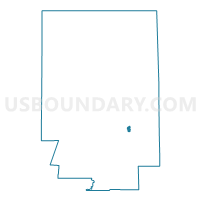
Voting District 0800061, Monroe County, New York
About
Outline

Summary
| Unique Area Identifier | 630050 |
| Name | Voting District 0800061 |
| County | Monroe County |
| State | New York |
| Area (square miles) | 0.67 |
| Land Area (square miles) | 0.57 |
| Water Area (square miles) | 0.10 |
| % of Land Area | 84.90 |
| % of Water Area | 15.10 |
| Latitude of the Internal Point | 43.17937060 |
| Longtitude of the Internal Point | -77.53502590 |
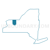
Maps

Graphs
Select a template below for downloading or customizing gragh for Voting District 0800061, Monroe County, New York


Neighbors
Neighoring Voting District (by Name) Neighboring Voting District on the Map
- Voting District 0100007, Monroe County, NY
- Voting District 0800011, Monroe County, NY
- Voting District 0800023, Monroe County, NY
- Voting District 0800029, Monroe County, NY
- Voting District 0800034, Monroe County, NY
- Voting District 0800052, Monroe County, NY
- Voting District 1200005, Monroe County, NY
- Voting District 1200013, Monroe County, NY
- Voting District 1623019 1623026, Monroe County, NY
Top 10 Neighboring County Subdivision (by Population) Neighboring County Subdivision on the Map
- Rochester city, Monroe County, NY (210,565)
- Irondequoit town, Monroe County, NY (51,692)
- Brighton town, Monroe County, NY (36,609)
- Penfield town, Monroe County, NY (36,242)
Top 10 Neighboring Place (by Population) Neighboring Place on the Map
Top 10 Neighboring Unified School District (by Population) Neighboring Unified School District on the Map
- Rochester City School District, NY (210,596)
- Webster Central School District, NY (55,982)
- Penfield Central School District, NY (30,712)
- East Irondequoit Central School District, NY (27,907)
Top 10 Neighboring State Legislative District Lower Chamber (by Population) Neighboring State Legislative District Lower Chamber on the Map
Top 10 Neighboring State Legislative District Upper Chamber (by Population) Neighboring State Legislative District Upper Chamber on the Map
Top 10 Neighboring 111th Congressional District (by Population) Neighboring 111th Congressional District on the Map
Top 10 Neighboring Census Tract (by Population) Neighboring Census Tract on the Map
- Census Tract 115.01, Monroe County, NY (6,667)
- Census Tract 115.03, Monroe County, NY (6,060)
- Census Tract 110, Monroe County, NY (5,160)
- Census Tract 125, Monroe County, NY (4,450)
- Census Tract 111, Monroe County, NY (4,103)
- Census Tract 61, Monroe County, NY (2,353)