


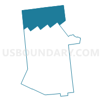
Voting District 070001, Hamilton County, New York
About
Outline

Summary
| Unique Area Identifier | 627395 |
| Name | Voting District 070001 |
| County | Hamilton County |
| State | New York |
| Area (square miles) | 367.03 |
| Land Area (square miles) | 334.91 |
| Water Area (square miles) | 32.12 |
| % of Land Area | 91.25 |
| % of Water Area | 8.75 |
| Latitude of the Internal Point | 44.00012540 |
| Longtitude of the Internal Point | -74.56387990 |
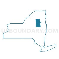
Maps

Graphs
Select a template below for downloading or customizing gragh for Voting District 070001, Hamilton County, New York


Neighbors
Neighoring Voting District (by Name) Neighboring Voting District on the Map
- Voting District 010001, Franklin County, NY
- Voting District 010001, Hamilton County, NY
- Voting District 040002, Hamilton County, NY
- Voting District 040002, St. Lawrence County, NY
- Voting District 050002, St. Lawrence County, NY
- Voting District 070002, Hamilton County, NY
- Voting District 080001, Essex County, NY
- Voting District 100001, Essex County, NY
- Voting District 140001, Franklin County, NY
- Voting District 190002, Herkimer County, NY
- Voting District 260001, St. Lawrence County, NY
Top 10 Neighboring County Subdivision (by Population) Neighboring County Subdivision on the Map
- Tupper Lake town, Franklin County, NY (5,971)
- Harrietstown town, Franklin County, NY (5,709)
- Webb town, Herkimer County, NY (1,807)
- Colton town, St. Lawrence County, NY (1,451)
- Indian Lake town, Hamilton County, NY (1,352)
- Minerva town, Essex County, NY (809)
- Clifton town, St. Lawrence County, NY (751)
- Long Lake town, Hamilton County, NY (711)
- Newcomb town, Essex County, NY (436)
- Piercefield town, St. Lawrence County, NY (310)
Top 10 Neighboring Place (by Population) Neighboring Place on the Map
Top 10 Neighboring Unified School District (by Population) Neighboring Unified School District on the Map
- Saranac Lake Central School District, NY (13,583)
- Tupper Lake Central School District, NY (6,283)
- Clifton-Fine Central School District, NY (2,257)
- Webb Town Union Free School District, NY (2,228)
- Indian Lake Central School District, NY (1,352)
- Minerva Central School District, NY (828)
- Long Lake Central School District, NY (597)
- Newcomb Central School District, NY (436)
- Raquette Lake Union Free School District, NY (114)
Top 10 Neighboring State Legislative District Lower Chamber (by Population) Neighboring State Legislative District Lower Chamber on the Map
- Assembly District 113, NY (135,737)
- Assembly District 114, NY (135,275)
- Assembly District 122, NY (131,778)
- Assembly District 117, NY (128,680)
Top 10 Neighboring State Legislative District Upper Chamber (by Population) Neighboring State Legislative District Upper Chamber on the Map
- State Senate District 45, NY (306,856)
- State Senate District 51, NY (296,420)
- State Senate District 47, NY (292,134)
Top 10 Neighboring 111th Congressional District (by Population) Neighboring 111th Congressional District on the Map
Top 10 Neighboring Census Tract (by Population) Neighboring Census Tract on the Map
- Census Tract 9509, Franklin County, NY (3,536)
- Census Tract 4925, St. Lawrence County, NY (2,693)
- Census Tract 115.02, Herkimer County, NY (2,258)
- Census Tract 9512, Franklin County, NY (1,987)
- Census Tract 9614, Essex County, NY (1,485)
- Census Tract 9503, Hamilton County, NY (1,352)
- Census Tract 9505, Hamilton County, NY (1,171)
- Census Tract 9501, Hamilton County, NY (1,044)
Top 10 Neighboring 5-Digit ZIP Code Tabulation Area (by Population) Neighboring 5-Digit ZIP Code Tabulation Area on the Map
- 13367, NY (8,830)
- 12986, NY (6,120)
- 12847, NY (605)
- 12852, NY (436)
- 12927, NY (224)
- 13331, NY (189)
- 12812, NY (150)
- 13436, NY (108)