


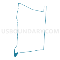
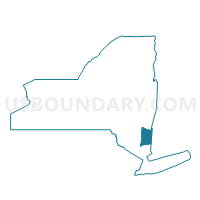
Voting District 070004, Dutchess County, New York
About
Outline

Summary
| Unique Area Identifier | 626350 |
| Name | Voting District 070004 |
| County | Dutchess County |
| State | New York |
| Area (square miles) | 7.92 |
| Land Area (square miles) | 4.54 |
| Water Area (square miles) | 3.38 |
| % of Land Area | 57.31 |
| % of Water Area | 42.69 |
| Latitude of the Internal Point | 41.47506280 |
| Longtitude of the Internal Point | -73.97685420 |
Maps

Graphs
Select a template below for downloading or customizing gragh for Voting District 070004, Dutchess County, New York


Neighbors
Neighoring Voting District (by Name) Neighboring Voting District on the Map
- Voting District 020101, Dutchess County, NY
- Voting District 020201, Dutchess County, NY
- Voting District 020402, Dutchess County, NY
- Voting District 030001, Orange County, NY
- Voting District 040007, Putnam County, NY
- Voting District 070013, Dutchess County, NY
- Voting District 070016, Dutchess County, NY
- Voting District 150001, Orange County, NY
- Voting District 160101, Orange County, NY
- Voting District 160103 160104, Orange County, NY
- Voting District 160201 160202 160301, Orange County, NY
- Voting District 160401, Orange County, NY
- Voting District 170001 170004, Orange County, NY
Top 10 Neighboring County Subdivision (by Population) Neighboring County Subdivision on the Map
- Newburgh town, Orange County, NY (29,801)
- Newburgh city, Orange County, NY (28,866)
- New Windsor town, Orange County, NY (25,244)
- Fishkill town, Dutchess County, NY (22,107)
- Beacon city, Dutchess County, NY (15,541)
- Cornwall town, Orange County, NY (12,646)
- Philipstown town, Putnam County, NY (9,662)
Top 10 Neighboring Place (by Population) Neighboring Place on the Map
Top 10 Neighboring Unified School District (by Population) Neighboring Unified School District on the Map
- Newburgh City School District, NY (65,923)
- Beacon City School District, NY (27,294)
- Cornwall Central School District, NY (16,841)
- Haldane Central School District, NY (5,421)
Top 10 Neighboring State Legislative District Lower Chamber (by Population) Neighboring State Legislative District Lower Chamber on the Map
- Assembly District 100, NY (140,947)
- Assembly District 96, NY (138,725)
- Assembly District 90, NY (137,827)
- Assembly District 102, NY (134,109)
Top 10 Neighboring State Legislative District Upper Chamber (by Population) Neighboring State Legislative District Upper Chamber on the Map
- State Senate District 39, NY (332,117)
- State Senate District 41, NY (316,491)
- State Senate District 40, NY (316,324)
Top 10 Neighboring 111th Congressional District (by Population) Neighboring 111th Congressional District on the Map
Top 10 Neighboring Census Tract (by Population) Neighboring Census Tract on the Map
- Census Tract 2101.01, Dutchess County, NY (5,328)
- Census Tract 131, Orange County, NY (5,094)
- Census Tract 102, Orange County, NY (5,018)
- Census Tract 128, Orange County, NY (4,962)
- Census Tract 4, Orange County, NY (4,957)
- Census Tract 5.02, Orange County, NY (4,578)
- Census Tract 2103.01, Dutchess County, NY (4,182)
- Census Tract 2102.01, Dutchess County, NY (4,129)
- Census Tract 602.02, Dutchess County, NY (3,997)
- Census Tract 106, Putnam County, NY (3,572)