


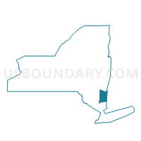
Voting District 100002, Dutchess County, New York
About
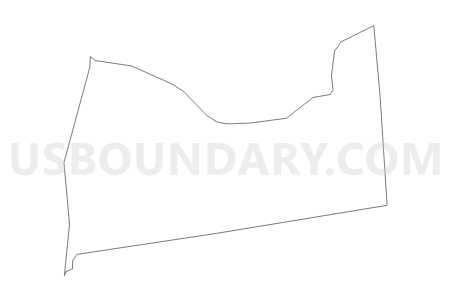
Outline

Summary
| Unique Area Identifier | 626213 |
| Name | Voting District 100002 |
| County | Dutchess County |
| State | New York |
| Area (square miles) | 14.96 |
| Land Area (square miles) | 14.75 |
| Water Area (square miles) | 0.20 |
| % of Land Area | 98.65 |
| % of Water Area | 1.35 |
| Latitude of the Internal Point | 41.94660280 |
| Longtitude of the Internal Point | -73.77229840 |
Maps


Graphs
Select a template below for downloading or customizing gragh for Voting District 100002, Dutchess County, New York


Neighbors
Neighoring Voting District (by Name) Neighboring Voting District on the Map
- Voting District 040001, Dutchess County, NY
- Voting District 040003 040004, Dutchess County, NY
- Voting District 100001, Dutchess County, NY
- Voting District 130001, Dutchess County, NY
- Voting District 170006, Dutchess County, NY
- Voting District 180002, Dutchess County, NY
- Voting District 180007, Dutchess County, NY
- Voting District 190001, Dutchess County, NY
Top 10 Neighboring County Subdivision (by Population) Neighboring County Subdivision on the Map
- Red Hook town, Dutchess County, NY (11,319)
- Rhinebeck town, Dutchess County, NY (7,548)
- Clinton town, Dutchess County, NY (4,312)
- Stanford town, Dutchess County, NY (3,823)
- Pine Plains town, Dutchess County, NY (2,473)
- Milan town, Dutchess County, NY (2,370)
Top 10 Neighboring Unified School District (by Population) Neighboring Unified School District on the Map
- Red Hook Central School District, NY (14,033)
- Rhinebeck Central School District, NY (9,711)
- Pine Plains Central School District, NY (9,080)
Top 10 Neighboring State Legislative District Lower Chamber (by Population) Neighboring State Legislative District Lower Chamber on the Map
- Assembly District 103, NY (134,686)
- Assembly District 102, NY (134,109)
- Assembly District 101, NY (128,454)
Top 10 Neighboring State Legislative District Upper Chamber (by Population) Neighboring State Legislative District Upper Chamber on the Map
Top 10 Neighboring 111th Congressional District (by Population) Neighboring 111th Congressional District on the Map
Top 10 Neighboring Census Tract (by Population) Neighboring Census Tract on the Map
- Census Tract 300, Dutchess County, NY (4,312)
- Census Tract 1700, Dutchess County, NY (3,823)
- Census Tract 1500.05, Dutchess County, NY (2,718)
- Census Tract 1600.04, Dutchess County, NY (2,530)
- Census Tract 1200, Dutchess County, NY (2,473)
- Census Tract 900, Dutchess County, NY (2,370)
- Census Tract 1600.03, Dutchess County, NY (2,361)