


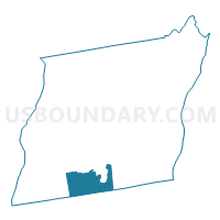
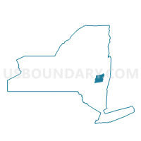
Voting District 130001, Albany County, New York
About
Outline

Summary
| Unique Area Identifier | 624592 |
| Name | Voting District 130001 |
| County | Albany County |
| State | New York |
| Area (square miles) | 19.67 |
| Land Area (square miles) | 19.62 |
| Water Area (square miles) | 0.04 |
| % of Land Area | 99.77 |
| % of Water Area | 0.23 |
| Latitude of the Internal Point | 42.45956740 |
| Longtitude of the Internal Point | -74.03758440 |
Maps

Graphs
Select a template below for downloading or customizing gragh for Voting District 130001, Albany County, New York


Neighbors
Neighoring Voting District (by Name) Neighboring Voting District on the Map
- Voting District 040007, Albany County, NY
- Voting District 060001, Greene County, NY
- Voting District 070001, Greene County, NY
- Voting District 070003, Greene County, NY
- Voting District 110003, Albany County, NY
- Voting District 130002, Albany County, NY
- Voting District 130003, Albany County, NY
Top 10 Neighboring County Subdivision (by Population) Neighboring County Subdivision on the Map
- Coeymans town, Albany County, NY (7,418)
- Greenville town, Greene County, NY (3,739)
- Westerlo town, Albany County, NY (3,361)
- Durham town, Greene County, NY (2,725)
- Rensselaerville town, Albany County, NY (1,843)
Top 10 Neighboring Place (by Population) Neighboring Place on the Map
Top 10 Neighboring Unified School District (by Population) Neighboring Unified School District on the Map
- Ravena-Coeymans-Selkirk Central School District, NY (14,064)
- Greenville Central School District, NY (8,326)
- Berne-Knox-Westerlo Central School District, NY (6,602)
Top 10 Neighboring State Legislative District Lower Chamber (by Population) Neighboring State Legislative District Lower Chamber on the Map
- Assembly District 104, NY (132,644)
- Assembly District 108, NY (131,716)
- Assembly District 127, NY (129,764)
Top 10 Neighboring State Legislative District Upper Chamber (by Population) Neighboring State Legislative District Upper Chamber on the Map
Top 10 Neighboring 111th Congressional District (by Population) Neighboring 111th Congressional District on the Map
Top 10 Neighboring Census Tract (by Population) Neighboring Census Tract on the Map
- Census Tract 144.01, Albany County, NY (4,151)
- Census Tract 802.01, Greene County, NY (3,739)
- Census Tract 148.03, Albany County, NY (3,361)
- Census Tract 802.02, Greene County, NY (2,725)
- Census Tract 148.02, Albany County, NY (1,843)
Top 10 Neighboring 5-Digit ZIP Code Tabulation Area (by Population) Neighboring 5-Digit ZIP Code Tabulation Area on the Map
- 12083, NY (3,795)
- 12193, NY (2,016)
- 12067, NY (1,506)
- 12087, NY (1,073)
- 12046, NY (817)
- 12120, NY (613)
- 12147, NY (499)
- 12042, NY (271)