


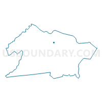
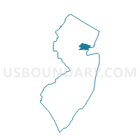
Union township voting district 48, Union County, New Jersey
About
Outline

Summary
| Unique Area Identifier | 622745 |
| Name | Union township voting district 48 |
| County | Union County |
| State | New Jersey |
| Area (square miles) | 0.03 |
| Land Area (square miles) | 0.03 |
| Water Area (square miles) | 0.00 |
| % of Land Area | 100.00 |
| % of Water Area | 0.00 |
| Latitude of the Internal Point | 40.68906610 |
| Longtitude of the Internal Point | -74.29079750 |
Maps

Graphs
Select a template below for downloading or customizing gragh for Union township voting district 48, Union County, New Jersey


Neighbors
Neighoring Voting District (by Name) Neighboring Voting District on the Map
- Kenilworth borough voting district 2, Union County, NJ
- Union township voting district 25, Union County, NJ
- Union township voting district 30, Union County, NJ
- Union township voting district 36, Union County, NJ