


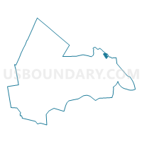
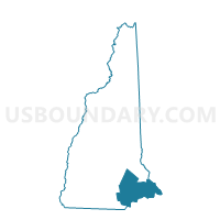
PORTSMOUTH WARD 1, Rockingham County, New Hampshire
About
Outline

Summary
| Unique Area Identifier | 616426 |
| Name | PORTSMOUTH WARD 1 |
| County | Rockingham County |
| State | New Hampshire |
| Area (square miles) | 1.49 |
| Land Area (square miles) | 1.33 |
| Water Area (square miles) | 0.16 |
| % of Land Area | 89.46 |
| % of Water Area | 10.54 |
| Latitude of the Internal Point | 43.08725520 |
| Longtitude of the Internal Point | -70.77859830 |
Maps
Graphs
Select a template below for downloading or customizing gragh for PORTSMOUTH WARD 1, Rockingham County, New Hampshire


Neighbors
Neighoring Voting District (by Name) Neighboring Voting District on the Map
- Voting District 011485, York County, ME
- Voting District 011495, York County, ME
- Voting District 011515, York County, ME
- PORTSMOUTH WARD 2, Rockingham County, NH
- PORTSMOUTH WARD 3, Rockingham County, NH
- PORTSMOUTH WARD 5, Rockingham County, NH
- TOWN OF NEWINGTON Voting District, Rockingham County, NH
Top 10 Neighboring County Subdivision (by Population) Neighboring County Subdivision on the Map
- Portsmouth city, Rockingham County, NH (20,779)
- Kittery town, York County, ME (9,490)
- Eliot town, York County, ME (6,204)
- Newington town, Rockingham County, NH (753)
Top 10 Neighboring Place (by Population) Neighboring Place on the Map
Top 10 Neighboring Elementary School District (by Population) Neighboring Elementary School District on the Map
Top 10 Neighboring Unified School District (by Population) Neighboring Unified School District on the Map
- Portsmouth School District, NH (20,779)
- School Administrative District 35, ME (13,424)
- Kittery, ME (9,490)
Top 10 Neighboring State Legislative District Lower Chamber (by Population) Neighboring State Legislative District Lower Chamber on the Map
- State House District 16, Rockingham County, NH (21,532)
- State House District 148, ME (8,974)
- State House District 149, ME (8,487)
Top 10 Neighboring State Legislative District Upper Chamber (by Population) Neighboring State Legislative District Upper Chamber on the Map
Top 10 Neighboring 111th Congressional District (by Population) Neighboring 111th Congressional District on the Map
Top 10 Neighboring Census Tract (by Population) Neighboring Census Tract on the Map
- Census Tract 370, York County, ME (6,204)
- Census Tract 1075, Rockingham County, NH (4,302)
- Census Tract 380.02, York County, ME (3,383)
- Census Tract 1071, Rockingham County, NH (2,465)
- Census Tract 693, Rockingham County, NH (2,065)