


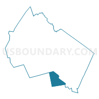
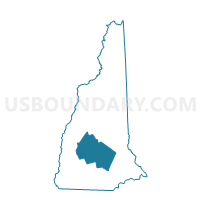
TOWN OF DUNBARTON Voting District, Merrimack County, New Hampshire
About
Outline

Summary
| Unique Area Identifier | 616397 |
| Name | TOWN OF DUNBARTON Voting District |
| County | Merrimack County |
| State | New Hampshire |
| Area (square miles) | 31.36 |
| Land Area (square miles) | 30.88 |
| Water Area (square miles) | 0.48 |
| % of Land Area | 98.48 |
| % of Water Area | 1.52 |
| Latitude of the Internal Point | 43.11245410 |
| Longtitude of the Internal Point | -71.60747990 |
Maps
Graphs
Select a template below for downloading or customizing gragh for TOWN OF DUNBARTON Voting District, Merrimack County, New Hampshire


Neighbors
Neighoring Voting District (by Name) Neighboring Voting District on the Map
- TOWN OF BOW Voting District, Merrimack County, NH
- TOWN OF GOFFSTOWN Voting District, Hillsborough County, NH
- TOWN OF HOOKSETT Voting District, Merrimack County, NH
- TOWN OF HOPKINTON Voting District, Merrimack County, NH
- TOWN OF WEARE Voting District, Hillsborough County, NH
Top 10 Neighboring County Subdivision (by Population) Neighboring County Subdivision on the Map
- Goffstown town, Hillsborough County, NH (17,651)
- Hooksett town, Merrimack County, NH (13,451)
- Weare town, Hillsborough County, NH (8,785)
- Bow town, Merrimack County, NH (7,519)
- Hopkinton town, Merrimack County, NH (5,589)
- Dunbarton town, Merrimack County, NH (2,758)
Top 10 Neighboring Elementary School District (by Population) Neighboring Elementary School District on the Map
- Hooksett School District, NH (13,451)
- Weare School District, NH (8,785)
- Dunbarton School District, NH (2,758)
Top 10 Neighboring Secondary School District (by Population) Neighboring Secondary School District on the Map
Top 10 Neighboring Unified School District (by Population) Neighboring Unified School District on the Map
- Goffstown School District, NH (17,651)
- Bow School District, NH (7,519)
- Hopkinton School District, NH (5,589)
Top 10 Neighboring State Legislative District Lower Chamber (by Population) Neighboring State Legislative District Lower Chamber on the Map
- State House District 7, Hillsborough County, NH (26,436)
- State House District 9, Merrimack County, NH (13,451)
- State House District 4, Merrimack County, NH (10,294)
- State House District 13, Merrimack County, NH (10,277)
Top 10 Neighboring State Legislative District Upper Chamber (by Population) Neighboring State Legislative District Upper Chamber on the Map
- State Senate District 16, NH (55,772)
- State Senate District 15, NH (55,399)
- State Senate District 7, NH (54,987)
- State Senate District 20, NH (52,778)
Top 10 Neighboring 111th Congressional District (by Population) Neighboring 111th Congressional District on the Map
Top 10 Neighboring Census Tract (by Population) Neighboring Census Tract on the Map
- Census Tract 210, Hillsborough County, NH (8,785)
- Census Tract 27.02, Hillsborough County, NH (6,029)
- Census Tract 390, Merrimack County, NH (5,589)
- Census Tract 30.01, Merrimack County, NH (4,168)
- Census Tract 310.01, Merrimack County, NH (3,874)
- Census Tract 27.01, Hillsborough County, NH (3,807)
- Census Tract 310.02, Merrimack County, NH (3,645)
- Census Tract 300, Merrimack County, NH (2,758)
Top 10 Neighboring 5-Digit ZIP Code Tabulation Area (by Population) Neighboring 5-Digit ZIP Code Tabulation Area on the Map
- 03045, NH (13,560)
- 03106, NH (13,374)
- 03281, NH (8,785)
- 03304, NH (7,519)
- 03229, NH (5,589)
- 03046, NH (2,758)