


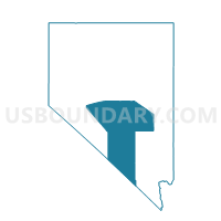
SUNNYSIDE PRECINCT 13, Nye County, Nevada
About
Outline

Summary
| Unique Area Identifier | 615428 |
| Name | SUNNYSIDE PRECINCT 13 |
| County | Nye County |
| State | Nevada |
| Area (square miles) | 1,136.15 |
| Land Area (square miles) | 1,134.27 |
| Water Area (square miles) | 1.88 |
| % of Land Area | 99.83 |
| % of Water Area | 0.17 |
| Latitude of the Internal Point | 38.31317830 |
| Longtitude of the Internal Point | -115.27283920 |
Maps


Graphs
Select a template below for downloading or customizing gragh for SUNNYSIDE PRECINCT 13, Nye County, Nevada


Neighbors
Neighoring Voting District (by Name) Neighboring Voting District on the Map
- CURRANT CREEK PRECINCT 02, Nye County, NV
- Precinct 1 - Alamo, Lincoln County, NV
- Precinct 4 - Pioche, Lincoln County, NV
- Precinct 5 - Rachel, Lincoln County, NV
- WP LUND VTD 8, White Pine County, NV
Top 10 Neighboring County Subdivision (by Population) Neighboring County Subdivision on the Map
- Pioche CCD, Lincoln County, NV (2,684)
- Alamo CCD, Lincoln County, NV (1,398)
- Lund CCD, White Pine County, NV (538)
- Duckwater CCD, Nye County, NV (228)
Top 10 Neighboring Unified School District (by Population) Neighboring Unified School District on the Map
- Nye County School District, NV (43,946)
- White Pine County School District, NV (10,030)
- Lincoln County School District, NV (5,345)
Top 10 Neighboring State Legislative District Lower Chamber (by Population) Neighboring State Legislative District Lower Chamber on the Map
Top 10 Neighboring State Legislative District Upper Chamber (by Population) Neighboring State Legislative District Upper Chamber on the Map
Top 10 Neighboring 111th Congressional District (by Population) Neighboring 111th Congressional District on the Map
Top 10 Neighboring Census Tract (by Population) Neighboring Census Tract on the Map
- Census Tract 9702, White Pine County, NV (5,919)
- Census Tract 9501, Lincoln County, NV (2,684)
- Census Tract 9502, Lincoln County, NV (2,661)
- Census Tract 9601, Nye County, NV (2,330)