


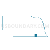
Hebron South Precinct, Thayer County, Nebraska
About
Outline

Summary
| Unique Area Identifier | 613975 |
| Name | Hebron South Precinct |
| County | Thayer County |
| State | Nebraska |
| Area (square miles) | 55.86 |
| Land Area (square miles) | 55.79 |
| Water Area (square miles) | 0.07 |
| % of Land Area | 99.88 |
| % of Water Area | 0.12 |
| Latitude of the Internal Point | 40.12541620 |
| Longtitude of the Internal Point | -97.56673630 |
Maps

Graphs
Select a template below for downloading or customizing gragh for Hebron South Precinct, Thayer County, Nebraska


Neighbors
Neighoring Voting District (by Name) Neighboring Voting District on the Map
- Alexandria-Gilead Precinct, Thayer County, NE
- Byron-Chester-Hubbell Precinct, Thayer County, NE
- Deshler Precinct, Thayer County, NE
- Hebron North Precinct, Thayer County, NE
Top 10 Neighboring County Subdivision (by Population) Neighboring County Subdivision on the Map
- Hebron city, Thayer County, NE (1,579)
- Deshler precinct, Thayer County, NE (981)
- Chester precinct, Thayer County, NE (696)
- Alexandria precinct, Thayer County, NE (431)
- Hebron South precinct, Thayer County, NE (206)
- Hebron North precinct, Thayer County, NE (126)