


Hebron North Precinct, Thayer County, Nebraska
About
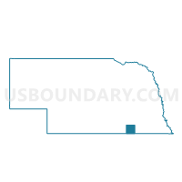
Outline

Summary
| Unique Area Identifier | 613974 |
| Name | Hebron North Precinct |
| County | Thayer County |
| State | Nebraska |
| Area (square miles) | 44.23 |
| Land Area (square miles) | 44.19 |
| Water Area (square miles) | 0.04 |
| % of Land Area | 99.91 |
| % of Water Area | 0.09 |
| Latitude of the Internal Point | 40.19649930 |
| Longtitude of the Internal Point | -97.57668690 |
Maps

Graphs
Select a template below for downloading or customizing gragh for Hebron North Precinct, Thayer County, Nebraska


Neighbors
Neighoring Voting District (by Name) Neighboring Voting District on the Map
- Alexandria-Gilead Precinct, Thayer County, NE
- Belvidere-Bruning Precinct, Thayer County, NE
- Davenport-Carleton Precinct, Thayer County, NE
- Deshler Precinct, Thayer County, NE
- Hebron South Precinct, Thayer County, NE
Top 10 Neighboring County Subdivision (by Population) Neighboring County Subdivision on the Map
- Hebron city, Thayer County, NE (1,579)
- Deshler precinct, Thayer County, NE (981)
- Davenport precinct, Thayer County, NE (677)
- Bruning precinct, Thayer County, NE (532)
- Alexandria precinct, Thayer County, NE (431)
- Hebron South precinct, Thayer County, NE (206)
- Hebron North precinct, Thayer County, NE (126)
Top 10 Neighboring Place (by Population) Neighboring Place on the Map
Top 10 Neighboring Unified School District (by Population) Neighboring Unified School District on the Map
- Thayer Central Community Schools, NE (2,761)
- Deshler Public Schools, NE (1,402)
- Bruning-Davenport Unified School System, NE (1,372)