


West Gordon Precinct, Sheridan County, Nebraska
About
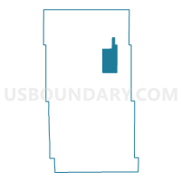
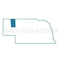
Outline

Summary
| Unique Area Identifier | 613949 |
| Name | West Gordon Precinct |
| County | Sheridan County |
| State | Nebraska |
| Area (square miles) | 65.96 |
| Land Area (square miles) | 65.79 |
| Water Area (square miles) | 0.17 |
| % of Land Area | 99.74 |
| % of Water Area | 0.26 |
| Latitude of the Internal Point | 42.69103420 |
| Longtitude of the Internal Point | -102.23286400 |
Maps

Graphs
Select a template below for downloading or customizing gragh for West Gordon Precinct, Sheridan County, Nebraska


Neighbors
Neighoring Voting District (by Name) Neighboring Voting District on the Map
- East Gordon Precinct, Sheridan County, NE
- North Rushville Precinct, Sheridan County, NE
- South Rushville Precinct, Sheridan County, NE
- South Sheridan Precinct, Sheridan County, NE
- Wounded Knee Precinct, Sheridan County, NE
Top 10 Neighboring County Subdivision (by Population) Neighboring County Subdivision on the Map
- Gordon city, Sheridan County, NE (1,612)
- South Sheridan precinct, Sheridan County, NE (546)
- North Rushville precinct, Sheridan County, NE (445)
- East Gordon precinct, Sheridan County, NE (226)
- West Gordon precinct, Sheridan County, NE (199)
- Wounded Knee precinct, Sheridan County, NE (178)
- South Rushville precinct, Sheridan County, NE (124)