


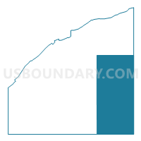
South Canada Precinct, Polk County, Nebraska
About
Outline

Summary
| Unique Area Identifier | 613742 |
| Name | South Canada Precinct |
| County | Polk County |
| State | Nebraska |
| Area (square miles) | 105.53 |
| Land Area (square miles) | 105.33 |
| Water Area (square miles) | 0.20 |
| % of Land Area | 99.81 |
| % of Water Area | 0.19 |
| Latitude of the Internal Point | 41.15588680 |
| Longtitude of the Internal Point | -97.43550290 |
Maps

Graphs
Select a template below for downloading or customizing gragh for South Canada Precinct, Polk County, Nebraska


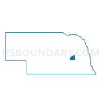
Neighbors
Neighoring Voting District (by Name) Neighboring Voting District on the Map
- C Precinct, Seward County, NE
- East Stromberg Precinct, Polk County, NE
- North Osceola Precinct, Polk County, NE
- Read Precinct, Butler County, NE
- Reading Precinct, Butler County, NE
- South Osceola Precinct, Polk County, NE
- Stewart Precinct, York County, NE
- Summit Precinct, Butler County, NE
- Thayer-Morton Precinct, York County, NE
Top 10 Neighboring County Subdivision (by Population) Neighboring County Subdivision on the Map
- South Canada precinct, Polk County, NE (1,201)
- South Osceola precinct, Polk County, NE (1,090)
- North Osceola precinct, Polk County, NE (987)
- East Stromsburg precinct, Polk County, NE (774)
- Reading township, Butler County, NE (521)
- Stewart precinct, York County, NE (392)
- Thayer precinct, York County, NE (221)
- Read township, Butler County, NE (181)
- Summit township, Butler County, NE (178)
- Precinct D, Seward County, NE (156)
Top 10 Neighboring Place (by Population) Neighboring Place on the Map
Top 10 Neighboring Unified School District (by Population) Neighboring Unified School District on the Map
- Centennial Public Schools, NE (3,378)
- Cross County Community Schools, NE (2,202)
- Osceola Public Schools, NE (1,612)
- Shelby Public Schools, NE (1,510)
- Rising City Public Schools, NE (609)
Top 10 Neighboring State Legislative District Upper Chamber (by Population) Neighboring State Legislative District Upper Chamber on the Map
- State Senate District 23, NE (40,859)
- State Senate District 34, NE (35,089)
- State Senate District 24, NE (34,230)
Top 10 Neighboring 111th Congressional District (by Population) Neighboring 111th Congressional District on the Map
Top 10 Neighboring Census Tract (by Population) Neighboring Census Tract on the Map
- Census Tract 9601, Seward County, NE (4,378)
- Census Tract 9676, Butler County, NE (3,327)
- Census Tract 9601, Polk County, NE (3,239)
- Census Tract 9696, York County, NE (2,711)
- Census Tract 9600, Polk County, NE (2,167)
- Census Tract 9678, Butler County, NE (1,958)
Top 10 Neighboring 5-Digit ZIP Code Tabulation Area (by Population) Neighboring 5-Digit ZIP Code Tabulation Area on the Map
- 68666, NE (1,611)
- 68651, NE (1,470)
- 68662, NE (1,231)
- 68658, NE (683)
- 68367, NE (461)
- 68316, NE (447)
- 68669, NE (422)
- 68667, NE (92)