


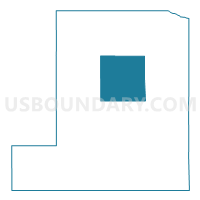
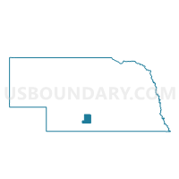
Precinct 1, Gosper County, Nebraska
About
Outline

Summary
| Unique Area Identifier | 613189 |
| Name | Precinct 1 |
| County | Gosper County |
| State | Nebraska |
| Area (square miles) | 35.29 |
| Land Area (square miles) | 35.15 |
| Water Area (square miles) | 0.14 |
| % of Land Area | 99.61 |
| % of Water Area | 0.39 |
| Latitude of the Internal Point | 40.55207090 |
| Longtitude of the Internal Point | -99.81014440 |
Maps

Graphs
Select a template below for downloading or customizing gragh for Precinct 1, Gosper County, Nebraska


Neighbors
Neighoring Voting District (by Name) Neighboring Voting District on the Map
Top 10 Neighboring County Subdivision (by Population) Neighboring County Subdivision on the Map
- Elwood 7-22 precinct, Gosper County, NE (812)
- Bethel precinct, Gosper County, NE (436)
- Harrison precinct, Gosper County, NE (175)
- Robb precinct, Gosper County, NE (125)
- Brace precinct, Gosper County, NE (112)
- Lincoln precinct, Gosper County, NE (79)
- Elwood 7-23 precinct, Gosper County, NE (78)
- East Muddy precinct, Gosper County, NE (35)
- Turkey Creek precinct, Gosper County, NE (29)