


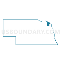
Springbank Precinct, Dixon County, Nebraska
About
Outline

Summary
| Unique Area Identifier | 612722 |
| Name | Springbank Precinct |
| County | Dixon County |
| State | Nebraska |
| Area (square miles) | 35.77 |
| Land Area (square miles) | 35.74 |
| Water Area (square miles) | 0.02 |
| % of Land Area | 99.93 |
| % of Water Area | 0.07 |
| Latitude of the Internal Point | 42.39768010 |
| Longtitude of the Internal Point | -96.84936360 |
Maps


Graphs
Select a template below for downloading or customizing gragh for Springbank Precinct, Dixon County, Nebraska


Neighbors
Neighoring Voting District (by Name) Neighboring Voting District on the Map
- Concord/Dixon/Clark Precinct, Dixon County, NE
- Emerson Precinct, Dixon County, NE
- Galena/Silvercreek Precinct, Dixon County, NE
- Logan/Wakefield 3 Precinct, Dixon County, NE
- Otter Precinct, Dixon County, NE
Top 10 Neighboring County Subdivision (by Population) Neighboring County Subdivision on the Map
- Wakefield township, Dixon County, NE (1,430)
- Springbank township, Dixon County, NE (570)
- Emerson township, Dixon County, NE (523)
- Concord township, Dixon County, NE (393)
- Galena township, Dixon County, NE (288)
- Ottercreek township, Dixon County, NE (235)
- Logan township, Dixon County, NE (206)
- Clark township, Dixon County, NE (154)
Top 10 Neighboring Place (by Population) Neighboring Place on the Map
Top 10 Neighboring Unified School District (by Population) Neighboring Unified School District on the Map
- Wakefield Public Schools, NE (2,119)
- Emerson-Hubbard Public Schools, NE (1,861)
- Allen Consolidated Schools, NE (1,001)