


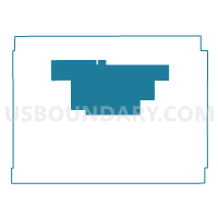
Gurley Precinct, Cheyenne County, Nebraska
About
Outline

Summary
| Unique Area Identifier | 612594 |
| Name | Gurley Precinct |
| County | Cheyenne County |
| State | Nebraska |
| Area (square miles) | 189.38 |
| Land Area (square miles) | 189.38 |
| Water Area (square miles) | 0.00 |
| % of Land Area | 100.00 |
| % of Water Area | 0.00 |
| Latitude of the Internal Point | 41.29292430 |
| Longtitude of the Internal Point | -102.99952640 |
Maps

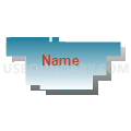
Graphs
Select a template below for downloading or customizing gragh for Gurley Precinct, Cheyenne County, Nebraska


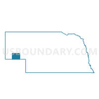
Neighbors
Neighoring Voting District (by Name) Neighboring Voting District on the Map
- Lodgepole Precinct, Cheyenne County, NE
- Potter Precinct, Cheyenne County, NE
- Sidney Precinct 2, Cheyenne County, NE
- Sidney Precinct 4, Cheyenne County, NE
- Union Valley Precinct, Cheyenne County, NE
Top 10 Neighboring County Subdivision (by Population) Neighboring County Subdivision on the Map
- Lodgepole precinct, Cheyenne County, NE (728)
- Potter precinct, Cheyenne County, NE (644)
- Union Valley precinct, Cheyenne County, NE (511)
- Gurley precinct, Cheyenne County, NE (506)
- Sidney 4 precinct, Cheyenne County, NE (425)
- Sidney 2 precinct, Cheyenne County, NE (170)
Top 10 Neighboring Place (by Population) Neighboring Place on the Map
Top 10 Neighboring Unified School District (by Population) Neighboring Unified School District on the Map
- Sidney Public Schools, NE (7,607)
- Leyton Public Schools, NE (1,312)
- Potter-Dix Public Schools, NE (1,051)