


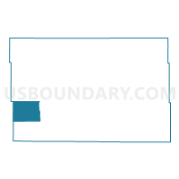
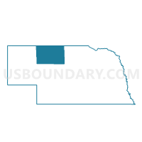
King Precinct, Cherry County, Nebraska
About
Outline

Summary
| Unique Area Identifier | 612573 |
| Name | King Precinct |
| County | Cherry County |
| State | Nebraska |
| Area (square miles) | 187.95 |
| Land Area (square miles) | 185.40 |
| Water Area (square miles) | 2.55 |
| % of Land Area | 98.65 |
| % of Water Area | 1.35 |
| Latitude of the Internal Point | 42.35185970 |
| Longtitude of the Internal Point | -101.88388520 |
Maps

Graphs
Select a template below for downloading or customizing gragh for King Precinct, Cherry County, Nebraska


Neighbors
Neighoring Voting District (by Name) Neighboring Voting District on the Map
- Lackey Precinct, Cherry County, NE
- Mother Lake Precinct, Cherry County, NE
- Russell Precinct, Cherry County, NE
- South Sheridan Precinct, Sheridan County, NE
Top 10 Neighboring County Subdivision (by Population) Neighboring County Subdivision on the Map
- South Sheridan precinct, Sheridan County, NE (546)
- Lackey precinct, Cherry County, NE (95)
- Mother Lake precinct, Cherry County, NE (77)
- Russell precinct, Cherry County, NE (47)
- Gillaspie precinct, Cherry County, NE (43)
- King precinct, Cherry County, NE (39)
Top 10 Neighboring Unified School District (by Population) Neighboring Unified School District on the Map
- Valentine Community Schools, NE (4,515)
- Gordon-Rushville Public Schools, NE (4,465)
- Hyannis Area Schools, NE (886)