


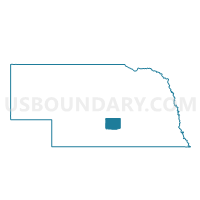
R-3 Precinct, Buffalo County, Nebraska
About
Outline

Summary
| Unique Area Identifier | 612484 |
| Name | R-3 Precinct |
| County | Buffalo County |
| State | Nebraska |
| Area (square miles) | 142.45 |
| Land Area (square miles) | 141.82 |
| Water Area (square miles) | 0.63 |
| % of Land Area | 99.56 |
| % of Water Area | 0.44 |
| Latitude of the Internal Point | 40.95273600 |
| Longtitude of the Internal Point | -98.82687050 |
Maps


Graphs
Select a template below for downloading or customizing gragh for R-3 Precinct, Buffalo County, Nebraska


Neighbors
Neighoring Voting District (by Name) Neighboring Voting District on the Map
- Cameron/Harrison Precinct, Hall County, NE
- Loup Fork Precinct, Howard County, NE
- Mayfield/South Loup Precinct, Hall County, NE
- R-2 Precinct, Buffalo County, NE
- R-7 Precinct, Buffalo County, NE
- Ravenna 1 Precinct, Buffalo County, NE
- Rockville Precinct, Sherman County, NE
- Shelton Precinct, Buffalo County, NE
- Wood River Rural/Jackson Precinct, Hall County, NE
Top 10 Neighboring County Subdivision (by Population) Neighboring County Subdivision on the Map
- Ravenna city, Buffalo County, NE (1,360)
- South Loup township, Hall County, NE (642)
- Rockville precinct, Sherman County, NE (486)
- Loup Fork precinct, Howard County, NE (392)
- Jackson township, Hall County, NE (332)
- Valley township, Buffalo County, NE (214)
- Garfield township, Buffalo County, NE (201)
- Cameron township, Hall County, NE (198)
- Cedar township, Buffalo County, NE (190)
- Beaver township, Buffalo County, NE (179)
Top 10 Neighboring Place (by Population) Neighboring Place on the Map
Top 10 Neighboring Unified School District (by Population) Neighboring Unified School District on the Map
- Wood River Rural Schools, NE (3,095)
- Gibbon Public Schools, NE (2,992)
- Centura Public Schools, NE (2,592)
- Ravenna Public Schools, NE (2,361)
- Shelton Public Schools, NE (1,584)
Top 10 Neighboring State Legislative District Upper Chamber (by Population) Neighboring State Legislative District Upper Chamber on the Map
- State Senate District 36, NE (37,224)
- State Senate District 33, NE (35,648)
- State Senate District 41, NE (33,249)
Top 10 Neighboring 111th Congressional District (by Population) Neighboring 111th Congressional District on the Map
Top 10 Neighboring Census Tract (by Population) Neighboring Census Tract on the Map
- Census Tract 9691, Buffalo County, NE (4,782)
- Census Tract 9706, Howard County, NE (4,580)
- Census Tract 9689, Buffalo County, NE (3,555)
- Census Tract 9701, Sherman County, NE (3,152)
- Census Tract 1, Hall County, NE (2,517)
- Census Tract 14, Hall County, NE (2,128)