


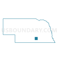
Verona Precinct, Adams County, Nebraska
About
Outline

Summary
| Unique Area Identifier | 612406 |
| Name | Verona Precinct |
| County | Adams County |
| State | Nebraska |
| Area (square miles) | 35.79 |
| Land Area (square miles) | 35.66 |
| Water Area (square miles) | 0.13 |
| % of Land Area | 99.65 |
| % of Water Area | 0.35 |
| Latitude of the Internal Point | 40.65975930 |
| Longtitude of the Internal Point | -98.54537860 |
Maps

Graphs
Select a template below for downloading or customizing gragh for Verona Precinct, Adams County, Nebraska


Neighbors
Neighoring Voting District (by Name) Neighboring Voting District on the Map
- Denver Precinct, Adams County, NE
- Juniata Precinct, Adams County, NE
- Kenesaw Precinct, Adams County, NE
- Martin/South Platte Precinct, Hall County, NE
- West Blue/Highland Precinct, Adams County, NE
Top 10 Neighboring County Subdivision (by Population) Neighboring County Subdivision on the Map
- Kenesaw township, Adams County, NE (1,003)
- Juniata township, Adams County, NE (999)
- Denver township, Adams County, NE (958)
- Highland township, Adams County, NE (326)
- Verona township, Adams County, NE (241)
- Wanda township, Adams County, NE (152)
- Martin township, Hall County, NE (129)
Top 10 Neighboring Place (by Population) Neighboring Place on the Map
Top 10 Neighboring Unified School District (by Population) Neighboring Unified School District on the Map
- Adams Central Public Schools, NE (5,278)
- Wood River Rural Schools, NE (3,095)
- Doniphan-Trumbull Public Schools, NE (2,557)
- Kenesaw Public Schools, NE (1,406)