


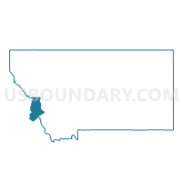
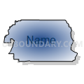
Precinct 12, Ravalli County, Montana
About
Outline

Summary
| Unique Area Identifier | 612233 |
| Name | Precinct 12 |
| County | Ravalli County |
| State | Montana |
| Area (square miles) | 174.75 |
| Land Area (square miles) | 174.46 |
| Water Area (square miles) | 0.28 |
| % of Land Area | 99.84 |
| % of Water Area | 0.16 |
| Latitude of the Internal Point | 46.35089000 |
| Longtitude of the Internal Point | -113.89496930 |
Maps


Graphs
Select a template below for downloading or customizing gragh for Precinct 12, Ravalli County, Montana


Neighbors
Neighoring Voting District (by Name) Neighboring Voting District on the Map
- Precinct 10, Ravalli County, MT
- Precinct 11, Ravalli County, MT
- Precinct 15, Ravalli County, MT
- Precinct 16, Ravalli County, MT
- Precinct 6, Ravalli County, MT
- Precinct 8, Ravalli County, MT
Top 10 Neighboring County Subdivision (by Population) Neighboring County Subdivision on the Map
- Hamilton CCD, Ravalli County, MT (19,785)
- Stevensville CCD, Ravalli County, MT (14,158)
- Victor CCD, Ravalli County, MT (2,889)
- Philipsburg CCD, Granite County, MT (1,815)
- Drummond CCD, Granite County, MT (1,264)
Top 10 Neighboring Place (by Population) Neighboring Place on the Map
Top 10 Neighboring Elementary School District (by Population) Neighboring Elementary School District on the Map
Top 10 Neighboring Secondary School District (by Population) Neighboring Secondary School District on the Map
Top 10 Neighboring Unified School District (by Population) Neighboring Unified School District on the Map
- Hamilton K-12 Schools, MT (11,122)
- Corvallis K-12 Schools, MT (7,645)
- Victor K-12 Schools, MT (3,486)
- Philipsburg K-12 Schools, MT (1,843)
Top 10 Neighboring State Legislative District Lower Chamber (by Population) Neighboring State Legislative District Lower Chamber on the Map
- State House District 89, MT (10,221)
- State House District 88, MT (9,867)
- State House District 87, MT (9,798)
- State House District 86, MT (8,842)
Top 10 Neighboring State Legislative District Upper Chamber (by Population) Neighboring State Legislative District Upper Chamber on the Map
- State Senate District 45, MT (20,547)
- State Senate District 44, MT (19,665)
- State Senate District 43, MT (17,466)
Top 10 Neighboring 111th Congressional District (by Population) Neighboring 111th Congressional District on the Map
Top 10 Neighboring Census Tract (by Population) Neighboring Census Tract on the Map
- Census Tract 2.02, Ravalli County, MT (6,666)
- Census Tract 6, Ravalli County, MT (6,144)
- Census Tract 4.02, Ravalli County, MT (5,423)
- Census Tract 9617, Granite County, MT (3,079)
- Census Tract 3, Ravalli County, MT (2,889)
- Census Tract 4.01, Ravalli County, MT (2,657)
Top 10 Neighboring 5-Digit ZIP Code Tabulation Area (by Population) Neighboring 5-Digit ZIP Code Tabulation Area on the Map
- 59840, MT (13,052)
- 59870, MT (9,617)
- 59828, MT (5,543)
- 59875, MT (3,537)
- 59825, MT (2,412)
- 59858, MT (1,538)