


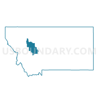
Precinct 45, Lewis and Clark County, Montana
About
Outline

Summary
| Unique Area Identifier | 612082 |
| Name | Precinct 45 |
| County | Lewis and Clark County |
| State | Montana |
| Area (square miles) | 1,165.13 |
| Land Area (square miles) | 1,156.86 |
| Water Area (square miles) | 8.27 |
| % of Land Area | 99.29 |
| % of Water Area | 0.71 |
| Latitude of the Internal Point | 47.48687960 |
| Longtitude of the Internal Point | -112.63544670 |
Maps


Graphs
Select a template below for downloading or customizing gragh for Precinct 45, Lewis and Clark County, Montana


Neighbors
Neighoring Voting District (by Name) Neighboring Voting District on the Map
- Precinct 18G, Cascade County, MT
- Precinct 19F, Cascade County, MT
- Precinct 42, Lewis and Clark County, MT
- Precinct 43, Lewis and Clark County, MT
- Precinct 44, Lewis and Clark County, MT
- Precinct 46, Lewis and Clark County, MT
- Voting Districts not defined, Flathead County, MT
Top 10 Neighboring County Subdivision (by Population) Neighboring County Subdivision on the Map
- Lincoln CCD, Lewis and Clark County, MT (5,929)
- Choteau CCD, Teton County, MT (3,146)
- Sun River Valley CCD, Cascade County, MT (2,840)
- Wolf Creek CCD, Lewis and Clark County, MT (2,513)
- South Fork CCD, Flathead County, MT (2,495)
- Fairfield CCD, Teton County, MT (1,809)
- Augusta CCD, Lewis and Clark County, MT (858)
- Helmville CCD, Powell County, MT (501)
Top 10 Neighboring Place (by Population) Neighboring Place on the Map
Top 10 Neighboring Elementary School District (by Population) Neighboring Elementary School District on the Map
- Columbia Falls Elementary School District, MT (14,331)
- Choteau Elementary School District, MT (2,582)
- Sun River Valley Elementary School District, MT (2,120)
- Fairfield Elementary School District, MT (1,245)
- Augusta Elementary School District, MT (662)
- Wolf Creek Elementary School District, MT (612)
- Ovando Elementary School District, MT (253)
- Golden Ridge Elementary School District, MT (160)
- Auchard Creek Elementary School District, MT (152)
Top 10 Neighboring Secondary School District (by Population) Neighboring Secondary School District on the Map
- Helena High School District, MT (61,307)
- Columbia Falls High School District, MT (14,817)
- Powell County High School District, MT (7,226)
- Choteau High School District, MT (3,118)
- Simms High School District, MT (3,030)
- Fairfield High School District, MT (1,900)
- Augusta High School District, MT (814)
Top 10 Neighboring Unified School District (by Population) Neighboring Unified School District on the Map
Top 10 Neighboring State Legislative District Lower Chamber (by Population) Neighboring State Legislative District Lower Chamber on the Map
- State House District 84, MT (10,853)
- State House District 18, MT (10,165)
- State House District 19, MT (9,944)
- State House District 15, MT (9,595)
- State House District 17, MT (8,272)
Top 10 Neighboring State Legislative District Upper Chamber (by Population) Neighboring State Legislative District Upper Chamber on the Map
- State Senate District 42, MT (20,506)
- State Senate District 8, MT (19,081)
- State Senate District 9, MT (18,437)
- State Senate District 10, MT (18,254)
Top 10 Neighboring 111th Congressional District (by Population) Neighboring 111th Congressional District on the Map
Top 10 Neighboring Census Tract (by Population) Neighboring Census Tract on the Map
- Census Tract 107, Cascade County, MT (4,455)
- Census Tract 1, Flathead County, MT (3,255)
- Census Tract 3, Lewis and Clark County, MT (2,513)
- Census Tract 3, Teton County, MT (2,445)
- Census Tract 1, Lewis and Clark County, MT (2,132)
- Census Tract 2, Teton County, MT (1,809)
- Census Tract 1, Powell County, MT (1,431)
Top 10 Neighboring 5-Digit ZIP Code Tabulation Area (by Population) Neighboring 5-Digit ZIP Code Tabulation Area on the Map
- 59422, MT (2,643)
- 59421, MT (1,831)
- 59436, MT (1,827)
- 59639, MT (1,286)
- 59919, MT (839)
- 59410, MT (666)
- 59648, MT (635)
- 59477, MT (521)