


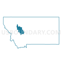
Precinct 26, Lewis and Clark County, Montana
About
Outline

Summary
| Unique Area Identifier | 612076 |
| Name | Precinct 26 |
| County | Lewis and Clark County |
| State | Montana |
| Area (square miles) | 46.37 |
| Land Area (square miles) | 46.32 |
| Water Area (square miles) | 0.05 |
| % of Land Area | 99.89 |
| % of Water Area | 0.11 |
| Latitude of the Internal Point | 46.61520750 |
| Longtitude of the Internal Point | -112.14993280 |
Maps


Graphs
Select a template below for downloading or customizing gragh for Precinct 26, Lewis and Clark County, Montana


Neighbors
Neighoring Voting District (by Name) Neighboring Voting District on the Map
- Precinct 1, Lewis and Clark County, MT
- Precinct 12, Lewis and Clark County, MT
- Precinct 2, Lewis and Clark County, MT
- Precinct 25, Lewis and Clark County, MT
- Precinct 27, Lewis and Clark County, MT
- Precinct 28, Lewis and Clark County, MT
- Precinct 29, Lewis and Clark County, MT
- Precinct 3, Lewis and Clark County, MT
- Precinct 39, Lewis and Clark County, MT
- Precinct 4, Lewis and Clark County, MT
- Precinct 5, Lewis and Clark County, MT
Top 10 Neighboring County Subdivision (by Population) Neighboring County Subdivision on the Map
Top 10 Neighboring Place (by Population) Neighboring Place on the Map
- Helena city, MT (28,190)
- Helena Valley West Central CDP, MT (7,883)
- Helena West Side CDP, MT (1,637)
Top 10 Neighboring Elementary School District (by Population) Neighboring Elementary School District on the Map
- Helena Elementary School District, MT (50,423)
- Trinity Elementary School District, MT (1,592)
- Elliston Elementary School District, MT (339)
Top 10 Neighboring Secondary School District (by Population) Neighboring Secondary School District on the Map
Top 10 Neighboring State Legislative District Lower Chamber (by Population) Neighboring State Legislative District Lower Chamber on the Map
- State House District 84, MT (10,853)
- State House District 77, MT (9,685)
- State House District 82, MT (9,424)
- State House District 81, MT (8,043)
Top 10 Neighboring State Legislative District Upper Chamber (by Population) Neighboring State Legislative District Upper Chamber on the Map
- State Senate District 42, MT (20,506)
- State Senate District 39, MT (20,393)
- State Senate District 41, MT (17,467)
Top 10 Neighboring 111th Congressional District (by Population) Neighboring 111th Congressional District on the Map
Top 10 Neighboring Census Tract (by Population) Neighboring Census Tract on the Map
- Census Tract 7, Lewis and Clark County, MT (6,816)
- Census Tract 5.02, Lewis and Clark County, MT (5,898)
- Census Tract 8, Lewis and Clark County, MT (4,305)
- Census Tract 6, Lewis and Clark County, MT (2,268)
- Census Tract 1, Powell County, MT (1,431)