


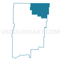
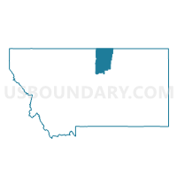
Precinct 1, Blaine County, Montana
About
Outline

Summary
| Unique Area Identifier | 611829 |
| Name | Precinct 1 |
| County | Blaine County |
| State | Montana |
| Area (square miles) | 584.46 |
| Land Area (square miles) | 583.66 |
| Water Area (square miles) | 0.79 |
| % of Land Area | 99.86 |
| % of Water Area | 0.14 |
| Latitude of the Internal Point | 48.86160700 |
| Longtitude of the Internal Point | -108.54305690 |
Maps

Graphs
Select a template below for downloading or customizing gragh for Precinct 1, Blaine County, Montana


Neighbors
Neighoring Voting District (by Name) Neighboring Voting District on the Map
Top 10 Neighboring County Subdivision (by Population) Neighboring County Subdivision on the Map
- Malta CCD, Phillips County, MT (3,539)
- Harlem CCD, Blaine County, MT (1,353)
- Whitewater CCD, Phillips County, MT (402)
Top 10 Neighboring Place (by Population) Neighboring Place on the Map
Top 10 Neighboring Elementary School District (by Population) Neighboring Elementary School District on the Map
- Harlem Elementary School District, MT (2,405)
- Zurich Elementary School District, MT (308)
- Turner Elementary School District, MT (306)
- Dodson Elementary School District, MT (306)
Top 10 Neighboring Secondary School District (by Population) Neighboring Secondary School District on the Map
- Harlem High School District, MT (2,533)
- Chinook High School District, MT (2,333)
- Dodson High School District, MT (350)
- Turner High School District, MT (303)