


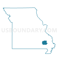
Coldwater Voting District, Wayne County, Missouri
About
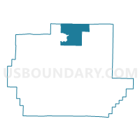
Outline

Summary
| Unique Area Identifier | 611556 |
| Name | Coldwater Voting District |
| County | Wayne County |
| State | Missouri |
| Area (square miles) | 37.25 |
| Land Area (square miles) | 37.01 |
| Water Area (square miles) | 0.23 |
| % of Land Area | 99.38 |
| % of Water Area | 0.62 |
| Latitude of the Internal Point | 37.26294700 |
| Longtitude of the Internal Point | -90.41497300 |
Maps

Graphs
Select a template below for downloading or customizing gragh for Coldwater Voting District, Wayne County, Missouri


Neighbors
Neighoring Voting District (by Name) Neighboring Voting District on the Map
- Brunot Voting District, Wayne County, MO
- Cascade Voting District, Wayne County, MO
- Central Voting District, Madison County, MO
- Clubb Voting District, Wayne County, MO
- Patterson Voting District, Wayne County, MO
- Silva Voting District, Wayne County, MO
Top 10 Neighboring County Subdivision (by Population) Neighboring County Subdivision on the Map
- St. Francois township, Wayne County, MO (2,094)
- Logan township, Wayne County, MO (1,486)
- Cowan township, Wayne County, MO (627)
- Cedar Creek township, Wayne County, MO (448)
- Twelvemile township, Madison County, MO (349)
- Liberty township, Madison County, MO (250)
Top 10 Neighboring Unified School District (by Population) Neighboring Unified School District on the Map
- Fredericktown R-I School District, MO (10,918)
- Clearwater R-I School District, MO (6,644)
- Greenville R-II School District, MO (5,601)
- Marquand-Zion School District, MO (1,261)
Top 10 Neighboring State Legislative District Lower Chamber (by Population) Neighboring State Legislative District Lower Chamber on the Map
Top 10 Neighboring State Legislative District Upper Chamber (by Population) Neighboring State Legislative District Upper Chamber on the Map
Top 10 Neighboring 111th Congressional District (by Population) Neighboring 111th Congressional District on the Map
Top 10 Neighboring Census Tract (by Population) Neighboring Census Tract on the Map
- Census Tract 6901, Wayne County, MO (3,603)
- Census Tract 9601, Madison County, MO (3,547)
- Census Tract 6902, Wayne County, MO (3,456)
Top 10 Neighboring 5-Digit ZIP Code Tabulation Area (by Population) Neighboring 5-Digit ZIP Code Tabulation Area on the Map
- 63645, MO (11,420)
- 63620, MO (1,619)
- 63655, MO (1,523)
- 63956, MO (1,133)
- 63964, MO (784)
- 63636, MO (608)
- 63934, MO (201)