


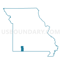
Pierce Voting District, Stone County, Missouri
About
Outline

Summary
| Unique Area Identifier | 611420 |
| Name | Pierce Voting District |
| County | Stone County |
| State | Missouri |
| Area (square miles) | 18.25 |
| Land Area (square miles) | 18.22 |
| Water Area (square miles) | 0.02 |
| % of Land Area | 99.87 |
| % of Water Area | 0.13 |
| Latitude of the Internal Point | 36.89361440 |
| Longtitude of the Internal Point | -93.56092470 |
Maps


Graphs
Select a template below for downloading or customizing gragh for Pierce Voting District, Stone County, Missouri


Neighbors
Neighoring Voting District (by Name) Neighboring Voting District on the Map
- Crane Creek Voting District, Barry County, MO
- Grant Voting District, Stone County, MO
- Hurley Voting District, Stone County, MO
- Lincoln Voting District, Stone County, MO
Top 10 Neighboring County Subdivision (by Population) Neighboring County Subdivision on the Map
- Pierce township, Stone County, MO (1,954)
- Hurley township, Stone County, MO (1,036)
- Crane Creek township, Barry County, MO (938)
- Lincoln township, Stone County, MO (781)
- Grant township, Stone County, MO (669)