


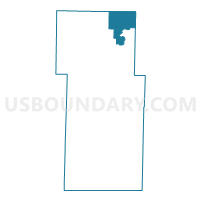
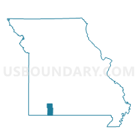
Cass Voting District, Stone County, Missouri
About
Outline

Summary
| Unique Area Identifier | 611417 |
| Name | Cass Voting District |
| County | Stone County |
| State | Missouri |
| Area (square miles) | 20.79 |
| Land Area (square miles) | 20.60 |
| Water Area (square miles) | 0.20 |
| % of Land Area | 99.05 |
| % of Water Area | 0.95 |
| Latitude of the Internal Point | 36.95681700 |
| Longtitude of the Internal Point | -93.38608620 |
Maps

Graphs
Select a template below for downloading or customizing gragh for Cass Voting District, Stone County, Missouri


Neighbors
Neighoring Voting District (by Name) Neighboring Voting District on the Map
- Hurley Voting District, Stone County, MO
- LINCOLN Voting District, Christian County, MO
- NORTH GALLOWAY Voting District, Christian County, MO
- Ponce de Leon Voting District, Stone County, MO
- ROSEDALE 2 Voting District, Christian County, MO
- Union Voting District, Stone County, MO
Top 10 Neighboring County Subdivision (by Population) Neighboring County Subdivision on the Map
- Rosedale township, Christian County, MO (9,501)
- Lincoln township, Christian County, MO (4,953)
- North Galloway township, Christian County, MO (3,626)
- Cass township, Stone County, MO (1,445)
- Hurley township, Stone County, MO (1,036)
- Ponce de Leon township, Stone County, MO (602)
- Union township, Stone County, MO (512)
Top 10 Neighboring Unified School District (by Population) Neighboring Unified School District on the Map
- Nixa School District, MO (28,372)
- Clever R-V School District, MO (5,906)
- Spokane R-VII School District, MO (4,750)
- Galena R-II School District, MO (3,750)
- Hurley R-I School District, MO (1,546)
Top 10 Neighboring State Legislative District Lower Chamber (by Population) Neighboring State Legislative District Lower Chamber on the Map
Top 10 Neighboring State Legislative District Upper Chamber (by Population) Neighboring State Legislative District Upper Chamber on the Map
Top 10 Neighboring 111th Congressional District (by Population) Neighboring 111th Congressional District on the Map
Top 10 Neighboring Census Tract (by Population) Neighboring Census Tract on the Map
- Census Tract 901, Stone County, MO (7,480)
- Census Tract 205, Christian County, MO (7,027)
- Census Tract 202.05, Christian County, MO (6,196)
- Census Tract 201.02, Christian County, MO (5,170)
- Census Tract 202.01, Christian County, MO (4,389)
Top 10 Neighboring 5-Digit ZIP Code Tabulation Area (by Population) Neighboring 5-Digit ZIP Code Tabulation Area on the Map
- 65714, MO (29,818)
- 65610, MO (5,239)
- 65656, MO (4,929)
- 65631, MO (4,678)
- 65633, MO (4,131)
- 65669, MO (2,031)