


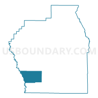
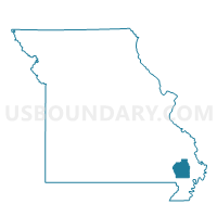
Pyle Voting District, Stoddard County, Missouri
About
Outline

Summary
| Unique Area Identifier | 611412 |
| Name | Pyle Voting District |
| County | Stoddard County |
| State | Missouri |
| Area (square miles) | 32.52 |
| Land Area (square miles) | 32.18 |
| Water Area (square miles) | 0.34 |
| % of Land Area | 98.95 |
| % of Water Area | 1.05 |
| Latitude of the Internal Point | 36.72169860 |
| Longtitude of the Internal Point | -90.09305670 |
Maps

Graphs
Select a template below for downloading or customizing gragh for Pyle Voting District, Stoddard County, Missouri


Neighbors
Neighoring Voting District (by Name) Neighboring Voting District on the Map
- Bernie Rural Voting District, Stoddard County, MO
- Broseley Voting District, Butler County, MO
- Dexter Rural Voting District, Stoddard County, MO
- Fisk Voting District, Butler County, MO
Top 10 Neighboring County Subdivision (by Population) Neighboring County Subdivision on the Map
Top 10 Neighboring Unified School District (by Population) Neighboring Unified School District on the Map
- Dexter R-XI School District, MO (12,958)
- Twin Rivers R-X School District, MO (5,956)
- Bernie School District, MO (3,151)
Top 10 Neighboring State Legislative District Lower Chamber (by Population) Neighboring State Legislative District Lower Chamber on the Map
- State House District 154, MO (36,484)
- State House District 159, MO (35,685)
- State House District 163, MO (33,118)
Top 10 Neighboring State Legislative District Upper Chamber (by Population) Neighboring State Legislative District Upper Chamber on the Map
Top 10 Neighboring 111th Congressional District (by Population) Neighboring 111th Congressional District on the Map
Top 10 Neighboring Census Tract (by Population) Neighboring Census Tract on the Map
- Census Tract 4702, Stoddard County, MO (4,573)
- Census Tract 9506, Butler County, MO (4,287)
- Census Tract 4708, Stoddard County, MO (3,033)