


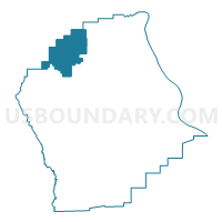
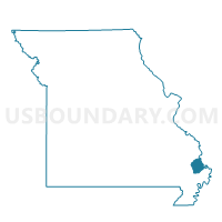
Chaffee Voting District, Scott County, Missouri
About
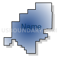
Outline

Summary
| Unique Area Identifier | 611357 |
| Name | Chaffee Voting District |
| County | Scott County |
| State | Missouri |
| Area (square miles) | 21.92 |
| Land Area (square miles) | 21.74 |
| Water Area (square miles) | 0.18 |
| % of Land Area | 99.16 |
| % of Water Area | 0.84 |
| Latitude of the Internal Point | 37.17269160 |
| Longtitude of the Internal Point | -89.65809930 |
Maps

Graphs
Select a template below for downloading or customizing gragh for Chaffee Voting District, Scott County, Missouri


Neighbors
Neighoring Voting District (by Name) Neighboring Voting District on the Map
- Delta Out County Voting District, Cape Girardeau County, MO
- Kelso Voting District, Scott County, MO
- New Hamburg Voting District, Scott County, MO
- Oran Voting District, Scott County, MO
Top 10 Neighboring County Subdivision (by Population) Neighboring County Subdivision on the Map
- Cape Girardeau township, Cape Girardeau County, MO (40,563)
- Kelso township, Scott County, MO (10,414)
- Moreland township, Scott County, MO (3,486)
- Sylvania township, Scott County, MO (2,252)
- Welch township, Cape Girardeau County, MO (1,231)
Top 10 Neighboring Place (by Population) Neighboring Place on the Map
Top 10 Neighboring Elementary School District (by Population) Neighboring Elementary School District on the Map
Top 10 Neighboring Unified School District (by Population) Neighboring Unified School District on the Map
- Scott County R-II School District, MO (3,816)
- Delta R-V School District, MO (2,142)
- Oran R-III School District, MO (2,135)
Top 10 Neighboring State Legislative District Lower Chamber (by Population) Neighboring State Legislative District Lower Chamber on the Map
Top 10 Neighboring State Legislative District Upper Chamber (by Population) Neighboring State Legislative District Upper Chamber on the Map
Top 10 Neighboring 111th Congressional District (by Population) Neighboring 111th Congressional District on the Map
Top 10 Neighboring Census Tract (by Population) Neighboring Census Tract on the Map
- Census Tract 8815, Cape Girardeau County, MO (4,483)
- Census Tract 8803, Cape Girardeau County, MO (4,387)
- Census Tract 7802, Scott County, MO (4,164)
- Census Tract 7803, Scott County, MO (2,729)