


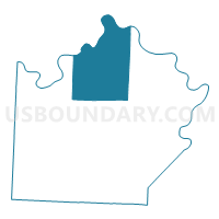
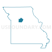
Miami Voting District, Saline County, Missouri
About
Outline

Summary
| Unique Area Identifier | 611328 |
| Name | Miami Voting District |
| County | Saline County |
| State | Missouri |
| Area (square miles) | 111.43 |
| Land Area (square miles) | 109.38 |
| Water Area (square miles) | 2.05 |
| % of Land Area | 98.16 |
| % of Water Area | 1.84 |
| Latitude of the Internal Point | 39.28642340 |
| Longtitude of the Internal Point | -93.20672610 |
Maps

Graphs
Select a template below for downloading or customizing gragh for Miami Voting District, Saline County, Missouri


Neighbors
Neighoring Voting District (by Name) Neighboring Voting District on the Map
- Cambridge Voting District, Saline County, MO
- Clay Voting District, Saline County, MO
- Combs/Eugene Voting District, Carroll County, MO
- Dewitt Voting District, Carroll County, MO
- Grand Pass Voting District, Saline County, MO
- Marshall Voting District, Saline County, MO
Top 10 Neighboring County Subdivision (by Population) Neighboring County Subdivision on the Map
- Marshall township, Saline County, MO (14,595)
- Cambridge township, Saline County, MO (2,431)
- Miami township, Saline County, MO (582)
- Grand Pass township, Saline County, MO (562)
- Clay township, Saline County, MO (419)
- De Witt township, Carroll County, MO (270)
- Eugene township, Carroll County, MO (163)
Top 10 Neighboring Place (by Population) Neighboring Place on the Map
Top 10 Neighboring Elementary School District (by Population) Neighboring Elementary School District on the Map
Top 10 Neighboring Unified School District (by Population) Neighboring Unified School District on the Map
- Carrollton R-VII School District, MO (5,621)
- Slater School District, MO (2,071)
- Brunswick R-II School District, MO (1,603)
- Malta Bend R-V School District, MO (669)
Top 10 Neighboring State Legislative District Lower Chamber (by Population) Neighboring State Legislative District Lower Chamber on the Map
Top 10 Neighboring State Legislative District Upper Chamber (by Population) Neighboring State Legislative District Upper Chamber on the Map
Top 10 Neighboring 111th Congressional District (by Population) Neighboring 111th Congressional District on the Map
Top 10 Neighboring Census Tract (by Population) Neighboring Census Tract on the Map
- Census Tract 908, Saline County, MO (2,575)
- Census Tract 9601, Carroll County, MO (2,530)
- Census Tract 902, Saline County, MO (2,525)
- Census Tract 901, Saline County, MO (2,483)
Top 10 Neighboring 5-Digit ZIP Code Tabulation Area (by Population) Neighboring 5-Digit ZIP Code Tabulation Area on the Map
- 65340, MO (15,937)
- 64633, MO (5,216)
- 65349, MO (2,441)
- 65339, MO (712)
- 65344, MO (332)
- 64639, MO (240)